M. Parsons, M. Thomas, R. Norris
Cooperative Research Centre for Freshwater Ecology
Monitoring River Health Initiative Technical Report Number 21
Environment Australia, 2002
ISSN 1447 1280
ISBN 0 642 54887 0
There are many stream assessment methods that have been developed worldwide. The methods chosen for inclusion in this review represent the suite of approaches currently in use in Australia. The State of the Rivers Survey, Index of Stream Condition and Geomorphic River Styles methods were developed for, and tested in, Australian rivers and streams. Thus, they tend to have an ability to incorporate stream features inherent to Australian conditions such as high flow variability, high turbidity and complex channel morphology. Although based on a method developed in the United Kingdom, the AusRivAS and Habitat Predictive Modelling methods have been successfully adapted to Australian conditions. In particular, AusRivAS is a nationally standardised and predictive approach to biological assessment that has recently been used to determine the condition of around 6000 river sites across Australia. The United States Environmental Protection Agency's HABSCORE method of stream assessment was used within the AusRivAS predictive model and thus, is included in this review. The River Habitat Survey is not currently being applied in Australia. However, it is included in this review because it represents an approach that was applied on a national scale in the United Kingdom, to assess the physical condition of streams and rivers.
There are some additional methods of stream assessment that were not included in the review. The Integrated Habitat Assessment System (IHAS) has been developed in South Africa and is used in conjunction with the country's rapid biological assessment program (McMillan, 1998). The IHAS measures components of the stream habitat relevant to macroinvertebrates, such as substratum, vegetation and physical stream condition. These components are rated and a score representing a continuum of habitat quality is derived. Another method, Pressure-Habitat-Biota (PBH), has been developed for use in small to medium sized rivers and streams in New South Wales (Chessman and Nancarrow, 1999). PBH measures variables representing the pressures on streams (e.g. physical restructuring, water pollution and introduced species), the habitat of streams (e.g. habitat area, habitat diversity and habitat stability) and the biota within streams (e.g. diatoms, riparian vegetation, water plants, macroinvertebrates and fish). These variables are then compared with each other to:
In addition to the IHAS and PBH methods, the United Kingdom's System for Evaluating Rivers for Conservation (SERCON) was also omitted from this review. SERCON is designed to assess the conservation value of rivers according to criteria of physical diversity, naturalness, representativeness, rarity, species richness and special features (Boon et al., 1998). Field data are collected using an extended version of the River Habitat Survey, and other data are gathered from a range of sources. Rating scores are derived for each variable and these scores are subsequently combined to produce indices for each of the conservation criteria described above (Boon et al., 1998).
Overall, the rationale for omission of IHAS, PBH and SERCON from this review is somewhat subjective and has no relationship to the mechanisms that each method uses to assess stream condition. Rather, the IHAS and PBH methods were omitted because they are still in the development stage and thus, there was a limited amount of literature available. SERCON is a complex system for evaluating conservation potential and thus, it was decided that the inclusion of SERCON's smaller sibling, the River Habitat Survey, would provide an adequate description of the potential for this method to assess physical stream condition.
The Australian River Assessment System (AusRivAS) was developed in response to the need for a nationally standardised method to assess the ecological condition of Australia's river systems (Simpson and Norris, 2000). The AusRivAS approach is based on the British River InVertebrate Predication and Classification System (RIVPACS, Wright et al., 1984; Moss et al., 1987), which has been successfully used to assess the quality of rivers in the U.K. (Wright et al., 1998). Initially, the adoption of RIVPACS to Australian conditions required modifications to the sampling design and statistical analysis components (Simpson and Norris, 2000). The major advantage of the AusRivAS and RIVPACS approaches to river assessment is that the fauna expected to occur at a site can be predicted, forming a 'target' community against which to measure potential ecological impairment.
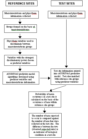
AusRivAS uses macroinvertebrate information as the basis upon which to assess the ecological condition of river sites (Figure 2.2.1). Macroinvertebrates are collected from reference sites, which are defined as sites representing least impaired conditions. Classification analysis is then used to form reference sites into groups containing similar biota. Physical and chemical data collected at reference sites are then used to discriminate among the biotic groups and the variables with the strongest discriminatory power are chosen as predictor variables for use in the AusRivAS predictive model algorithm.
The reference site information forms the templet against which test sites are compared to assess their ecological condition (Figure 2.2.1). A test site is defined as any new site for which an assessment is required. Macroinvertebrates are collected at the test sites, along with a suite of physical and chemical information that includes the predictor variables chosen for use in the AusRivAS model. These predictor variables are used to place test sites into the reference site groups formed on the basis of the biota. The model then calculates the probability of occurrence of each taxon at a test site, based on the occurrence of each taxon within the corresponding reference site groups. The number of taxa predicted to occur at a test site is compared against the number of taxa that were actually collected at the test site, with the difference between the two being an indication of the ecological condition of the site.
Figure 2.2.1 Schematic representation of AusRivAS assessment of site condition.
Macroinvertebrates are a commonly used group of organisms in the biological monitoring of water quality (Rosenberg and Resh, 1993). From an ecological perspective, the advantages of using macroinvertebrates to assess river condition are that they are common in many different river habitats, they show responses to a wide range of environmental stresses and they act as continuous monitors of the water that they inhabit (Rosenberg and Resh, 1993). Thus, the ecological foundation upon which biological monitoring is based is that the structure of the benthic macroinvertebrate community indicates the state of the entire ecosystem (Reice and Wohlenberg, 1993).
AusRivAS assesses site condition by comparing the macroinvertebrates that are predicted to occur at a test site, with the macroinvertebrates that were collected at a test site. The deviation between the number of taxa expected to occur and the number of taxa that were actually observed (observed:expected ratio) is a measure of the ecological condition of a site. If the number, or type, of taxa collected at a test site does not fulfil expectations, then it is likely that water quality or habitat conditions are limiting the biological potential of the site. The observed:expected ratio ranges from 0 to > 1 and represents a continuum of ecological condition. For ease of interpretation, the continuum can be broken into bands that delineate an ecological condition that is impoverished, well below reference, below reference, reference, and richer than reference (Simpson and Norris, 2000).
The robustness of AusRivAS assessments of site condition are enhanced through the use of a regional reference condition approach (Reynoldson et al., 1997). Comparison of test sites to groups of reference sites that represent an array of potential regional conditions enables prediction of the taxa likely to occur at sites with given environmental characteristics (Moss et al., 1987; Reynoldson et al., 1997). In predicting the taxa that should occur at a test site, the AusRivAS model calculates the weighted probabilities of a test site belonging to each of the reference site groups, which in turn enables natural variation in macroinvertebrate habitat associations to be accounted for before determining site condition. However, there are several limitations of the AusRivAS predictive models that currently have the potential to affect assessments of site condition. First, to allow accurate matching of test sites with reference site groups, reference sites must cover a wide range of river types. Secondly, evaluation of whether macroinvertebrate community impairment detected by AusRivAS is likely to be caused by water quality degradation, habitat degradation, or a combination of both is highly dependent upon the collection of the appropriate supporting data from each test site.
The fundamental assumption behind AusRivAS is that the physical and chemical factors measured at any site are directly related to the macroinvertebrates. This assumption is derived from a multitude of studies that have demonstrated specific physical and chemical influences on macroinvertebrate community structure in streams (Resh and Rosenberg, 1984; Vinson and Hawkins, 1998; Ward, 1992). The empirical evidence linking macroinvertebrates with their environmental requirements provides a strong foundation for the process that AusRivAS uses to link physical and chemical variables to taxon occurrence, and the subsequent assessments of ecological condition that are derived from this information.
The physical and chemical variables collected in AusRivAS broadly encompass the factors that influence the distribution of macroinvertebrates on a catchment, reach and individual habitat scale. These factors are geographical position, riparian vegetation, channel morphology, water chemistry, habitat composition, habitat characteristics, organic substratum, inorganic substratum and hydrology (Table 2.2.1). Within each factor, a number of different variables are measured to represent specific influences on macroinvertebrate communities (Table 2.2.1). In addition, the US EPA habitat assessment (see Section 2.3) is also performed at each site and a suite of observations that indicate potential human influences are recorded and used to aid interpretation of AusRivAS biological outputs (Table 2.2.1). However, there are several shortcomings of the physical and chemical data that may affect the AusRivAS assessments of ecological condition. Firstly, AusRivAS sampling is conducted by State agencies. As such, the specific variables measured in each State vary slightly according to both geographical and administrative need, although the major factors influencing macroinvertebrate distribution are generally encompassed by each State. Secondly, AusRivAS assumes a deterministic link between physical and chemical factors and macroinvertebrates, and thus, the predictive capability of the model depends on the ability to capture the variables that most strongly influence macroinvertebrate distribution. While the choice of variables included in the models has a strong empirical basis, it is not clear whether these variables encompass all the potential influences on macroinvertebrate communities. In particular, variables that represent habitat forming geomorphological processes, such as stream power and channel dimension, are omitted from AusRivAS. However, the relationship between the habitats that these geomorphological processes form, and the habitat requirements of macroinvertebrates is a contentious issue that has only recently come to the fore of research agendas.
|
Geographical position
Riparian vegetation
Channel morphology
Water chemistry
Hydrology
Habitat composition
Reach organic and inorganic substratum
|
Riffle/channel/sand bed habitat characteristics
Edge/backwater/macrophyte habitat characteristics
Habitat quality assessment (US EPA)
Site observations
|