M. Parsons, M. Thomas, R. Norris
Cooperative Research Centre for Freshwater Ecology
Monitoring River Health Initiative Technical Report Number 21
Environment Australia, 2002
ISSN 1447 1280
ISBN 0 642 54887 0
The United States Environmental Protection Agency (USEPA) has developed Rapid Bioassessment Protocols (RBP) that use fish, macroinvertebrates or periphyton to assess stream condition. Metrics representing structural, functional and process elements of the biotic community are calculated for each site, and aggregated into an index. This multimetric index represents the biological condition of a site (Barbour et al., 1999). Physical and chemical data are also measured at each site, and are used to aid the interpretation and calibration of the index, and also to define the reference condition. It is beyond the scope of this document to consider the process of biological metric calculation and calibration. Rather, the focus will be on the suite of physical and chemical measurements that are collected alongside the biota. In particular, the RBP includes a rapid habitat assessment method that uses a scoring system to rate habitat condition, and which will henceforth be referred to as HABSCORE. HABSCORE has utility outside the Rapid Bioassessment Protocols and has been used as a measure of habitat condition in the AusRivAS predictive models (see Section 2.2) and in the Habitat Predictive Modelling approach (see Section 2.7). HABSCORE was originally adopted by Plafkin et al. (1989) from work conducted on fish habitat, but has subsequently been updated and modified slightly by Barbour et al. (1999). The following discussion refers to the updated version of HABSCORE.
The USEPA Rapid Bioassessment Protocols were developed in response to a need for cost effective survey techniques to assess stream condition (Barbour et al., 1999). The principal requirements underpinning the protocols were:
The HABSCORE component of the Rapid Bioassessment Protocols is commensurate with these requirements.
HABSCORE is a visually based habitat assessment that evaluates 'the structure of the surrounding physical habitat that influences the quality of the water resource and the condition of the resident aquatic community' (Barbour et al., 1999, p5-5). It includes factors that characterise stream habitat on a micro-scale (e.g. embeddedness) and a macro-scale (e.g. channel morphology), as well as factors such as riparian and bank structure which influence the micro and macro-scale features (Barbour, 1991; Barbour et al., 1999). HABSCORE is composed of ten habitat parameters (Figure 2.3.1). To reflect the difference in habitat types between upland and lowland streams, separate assessments have been developed for high and low gradient conditions (Barbour et al., 1999). At each site, individual parameters are assessed and rated according to a continuum of scores that represent optimal, sub-optimal, marginal or poor condition (Figure 2.3.1). A total score is obtained for each site, and is subsequently used to determine the percent comparability to reference conditions (Plafkin et al., 1989). However, the individual parameter scores and the total assessment score also provide an overall assessment of habitat condition at the sampling site.
| HABITAT ASSESSMENT FIELD DATA SHEET | |
| HIGH GRADIENT STREAMS | |
| Date: _______________ | Recorders Name: ______________________________ |
| Site No.: _______________ | River and Location: ______________________________ |
| Habitat parameter |
Condition category |
||||||||||||||||||||
| Excellent | Good | Fair | Poor | ||||||||||||||||||
| 1. Epifaunal (bottom) substrate / available cover | Greater than 70% of substrate favourable for epifaunal colonisation and fish cover; mix of snags, submerged logs, undercut banks, cobble or other stable habitat and at stage to allow full colonisation potential (i.e. logs/snags that are not new fall and not transient). | 40-70% mix of stable habitat; well-suited for full colonisation potential; adequate habitat for maintenance of populations; presence of additional substrate in the form of newfall, but not yet prepared for colonisation (may rate at high end of scale). | 20-40% mix of stable habitat; habitat availability less than desirable; substrate frequently disturbed or removed. | Less than 20% stable habitat; lack of habitat is obvious; substrate unstable or lacking. | |||||||||||||||||
| SCORE | 20 | 19 | 18 | 17 | 16 | 15 | 14 | 13 | 12 | 11 |
10 |
9 |
8 |
7 |
6 |
5 |
4 |
3 |
2 | 1 | 0 |
| 2. Embeddedness | Gravel, cobble and boulder particles are 0-25% surrounded by fine sediment. Layering of cobble provides diversity of niche space. | Gravel, cobble and boulder particles are 25-50% surrounded by fine sediment. | Gravel, cobble and boulder particles are 50-75% surrounded by fine sediment. | Gravel, cobble and boulder particles are more than 75% surrounded by fine sediment. | |||||||||||||||||
| SCORE | 20 | 19 | 18 | 17 | 16 | 15 | 14 | 13 | 12 | 11 | 10 |
9 |
8 |
7 |
6 |
5 |
4 |
3 |
2 |
1 | 0 |
| 3. Velocity / depth regime | All four velocity/depth regimes present (slow-deep, slow-shallow, fast-deep, fast-shallow). Slow is <0.3m/s, deep is >0.5m). | Only 3 of the 4 regimes present (if fast-shallow is missing, score lower than if missing other regimes). | Only 2 of the 4 habitat regimes present (if fast-shallow or slow-shallow are missing, score low). | Dominated by 1 velocity/depth regime (usually slow-deep). | |||||||||||||||||
| SCORE | 20 | 19 | 18 | 17 | 16 | 15 | 14 | 13 | 12 | 11 | 10 | 9 |
8 |
7 |
6 |
5 |
4 |
3 |
2 |
1 |
0 |
| 4. Sediment deposition | Little or no enlargement of islands or point bars and less than 5% of the bottom affected by sediment deposition. | Some new increase in bar formation, mostly from gravel, sand or fine sediment; 5-30% of the bottom affected; slight deposition in pools. | Moderate deposition of new gravel, sand or fine sediment on old and new bars; 30-50% of the bottom affected; sediment deposits at obstructions, constrictions and bends; moderate deposition in pools prevalent. | Heavy deposits of fine material, increased bar development; more than 50% of the bottom changing frequently; pools almost absent due to substantial sediment deposition. | |||||||||||||||||
| SCORE | 20 | 19 | 18 | 17 | 16 | 15 | 14 | 13 | 12 | 11 | 10 | 9 | 8 |
7 |
6 |
5 |
4 |
3 |
2 |
1 |
0 |
| 5. Channel flow status | Water reaches base of both lower banks, and minimal amount of channel substrate is exposed. | Water fills >75% of the available channel; or <25% of channel substrate is exposed. | Water fills 25-75% of the available channel, and/or riffle substrates are mostly exposed. | Very little water in channel and mostly present as standing pools. | |||||||||||||||||
| SCORE | 20 | 19 | 18 | 17 | 16 | 15 | 14 | 13 | 12 | 11 | 10 | 9 | 8 | 7 |
6 |
5 |
4 |
3 |
2 |
1 |
0 |
| 6. Channel alteration | Channelization or dredging absent or minimal; stream with normal pattern. | Some channelization present, usually in areas of bridge abutments; evidence of past channelization, i.e. dredging (greater than 20 yr) may be present, but recent channelization is not present. | Channelization may be extensive; embankments or shoring structures present on both banks; and 40 to 80% of stream reach channelized and disrupted. | Banks shored with gabion or cement; over 80% of the stream reach channelized and disrupted. Instream habitat greatly altered or removed entirely. | |||||||||||||||||
| SCORE | 20 | 19 | 18 | 17 | 16 | 15 | 14 | 13 | 12 | 11 | 10 | 9 | 8 | 7 |
6 |
5 |
4 |
3 |
2 |
1 |
0 |
| HABITAT ASSESSMENT FIELD DATA SHEET | |
| HIGH GRADIENT STREAMS | |
| Date: _______________ | Recorders Name: ______________________________ |
| Site No.: _______________ | River and Location: ______________________________ |
|
Habitat parameter
|
Condition category | |||||||||||||||||||||
|---|---|---|---|---|---|---|---|---|---|---|---|---|---|---|---|---|---|---|---|---|---|---|
| Excellent | Good | Fair | Poor | |||||||||||||||||||
|
7.Frequency of riffles (or bends)
|
Occurrence of riffles relatively frequent; ratio of distance between riffles divided by width of the stream <7:1 (generally 5 to 7); variety of habitat is key. In streams where riffles are continuous, placement of boulders or other large, natural obstruction is important. | Occurrence of riffles infrequent; distance between riffles divided by the width of the stream is between 7 to 15. | Occasional riffle or bend; bottom contours provide some habitat; distance between riffles divided by the width of the stream is between 15 to 25. | Generally all flat water or shallow riffles; poor habitat; distance between riffles divided by the width of the stream is a ratio of >25. | ||||||||||||||||||
|
SCORE
|
20 | 19 | 18 | 17 | 16 | 15 | 14 | 13 | 12 | 11 | 10 | 9 | 8 | 7 | 6 | 5 | 4 | 3 | 2 | 1 | ||
|
8.Bank stability (score each bank)
|
Banks stable; evidence of erosion or bank failure absent or minimal; little potential for future problems. <5% of bank affected. | Moderately stable; infrequent, small areas of erosion mostly healed over. 5-30% of bank in reach has areas of erosion. | Moderately unstable; 30-60% of bank in reach has areas of erosion; high erosion potential during floods. | Unstable; many eroded areas; 'raw' areas frequent along straight sections and bends; obvious bank sloughing; 60-100% of bank has erosional scars. | ||||||||||||||||||
|
SCORE Left bank 10 9 8 7 6 5 4 3 2 1 0
|
||||||||||||||||||||||
|
SCORE Right bank 10 9 8 7 6 5 4 3 2 1 0
|
||||||||||||||||||||||
|
9.Vegetative protection (score each bank)
|
More than 90% of the streambank surfaces and immediate riparian zone covered by native vegetation, including trees, understorey shrubs, or non woody macrophytes; vegetative disruption through grazing or mowing minimal or not evident; almost all plants allowed to grow naturally. | 70-90% of the streambank surfaces covered by native vegetation, but one class of plants is not well-represented; disruption evident but not affecting full plant growth potential to any great extent; more than one half of the potential plant stubble height remaining. | 50-70% of the streambank surfaces covered by vegetation; disruption obvious; patches of bare soil or closely cropped vegetation common; less than one-half of the potential plant stubble height remaining. | Less than 50% of the streambank surfaces covered by vegetation; disruption of streambank vegetation is very high; vegetation has been removed to 5 centimetres or less in average stubble height. | ||||||||||||||||||
|
SCORE Left bank 10 9 8 7 6 5 4 3 2 1 0
|
||||||||||||||||||||||
|
SCORE Right bank 10 9 8 7 6 5 4 3 2 1 0
|
||||||||||||||||||||||
|
10.Riparian zone score(score each bank)
|
Width of riparian zone >18 metres; human activities (i.e. roads, lawns, crops etc.) have not impacted the riparian zone. | Width of riparian zone 12-18 metres; human activities have impacted riparian zone only minimally. | Width of riparian zone 6-12 metres; human activities have impacted zone a great deal. | Width of riparian zone <6 metres; little or no riparian vegetation is present because of human activities. | ||||||||||||||||||
|
SCORE Left bank 10 9 8 7 6 5 4 3 2 1 0
|
||||||||||||||||||||||
|
SCORE Right bank 10 9 8 7 6 5 4 3 2 1 0
|
||||||||||||||||||||||
TOTAL HABITAT SCORE _________________
Figure 2.3.1 Habitat assessment data sheet for high gradient streams, showing habitat parameters assessed for HABSCORE. Each parameter is scored on a continuum of conditions representing optimal, sub-optimal, marginal and poor conditions. The score is totalled and to form the overall assessment of habitat quality. After Barbour et al. (1999).
In addition to the HABSCORE assessment of site condition, a suite of variables that represent factors integrated within HABSCORE are also collected at each site. These factors characterise stream type, watershed features, riparian vegetation, instream features, large woody debris, aquatic vegetation, water quality, inorganic substrate and organic substrate (Table 2.3.1). These factors can be included in determinations of reference condition, but are mostly used as an interpretative aid to the assessments of stream condition, made using the multimetric indices. These variables are also collected in AusRivAS (see Section 2.2) but are used mainly to aid interpretation of site condition, rather than as predictor variables.
|
Watershed features
Riparian Vegetation
Instream features
Large woody debris
|
Aquatic vegetation
Water quality
Inorganic sediment/substrate
Organic substrate
|
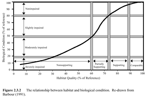
As a stand-alone method, HABSCORE provides an ability to assess the quality of instream and riparian habitat at a sampling site. However, a more important function of HABSCORE is that it is used to determine the ability of the habitat to support the optimal biological condition of the region (Barbour et al., 1999). Assuming that reference sites represent optimal condition, the comparability of the habitat and the biota to this reference state can be plotted to determine the ability of the habitat to support the biological community (Figure 2.3.2). There are three important aspects of Figure 2.3.2:
Apart from the three situations outlined above, comparison of the condition of the biota with the condition of the habitat can also highlight situations of potential water quality degradation, where habitat quality is high but biological condition is poor (Barbour et al., 1999).
Habitat quality is the initial focus of the Rapid Bioassessment Protocols. Habitat quality at the reference sites is compared against habitat quality at the test site and if equivalent, then a direct comparison of the biological condition can be made using the biological metrics (Plafkin et al., 1989). This ensures that assessments of biological condition indicate impairment, rather than inherent natural differences in stream habitat. If habitat quality is lower at a test site than at the reference sites, then the ability of the habitat to support biota is investigated as a first step, before a determination of biological condition is made (Plafkin et al., 1989).
HABSCORE was designed to complement assessments of biological condition made using the rapid biological assessment protocols. This compatibility is based on the assumption that the quality and quantity of available physical habitat has a direct influence on biotic communities (Maddock 1999; Rankin, 1995). The parameters measured in HABSCORE (Figure 2.3.1) represent aspects of the habitat that are related to aquatic life use and which are a potential source of limitation to the aquatic biota (Barbour, 1991; Barbour et al., 1999). Thus, the empirical links between habitat and the biota are reflected in this relationship. The process used to determine the ability of the habitat to support an optimal biological community (see Section 2.3.3) also captures these empirical links by considering habitat quality to be a templet that influences the types of biotic communities that can potentially be attained under certain conditions.
Figure 2.3.2 The relationship between habitat and biological condition. Re-drawn from Barbour (1991).