M. Parsons, M. Thomas, R. Norris
Cooperative Research Centre for Freshwater Ecology
Monitoring River Health Initiative Technical Report Number 21
Environment Australia, 2002
ISSN 1447 1280
ISBN 0 642 54887 0
Habitat Predictive Modelling is a new, novel method that adds a predictive capacity to assessment of the physical condition of rivers (Davies et al., 2000). As with AusRivAS (see Section 2.2), the major advantage of Habitat Predictive Modelling is that the features expected to occur at a site can be predicted, thus forming a target condition against which to measure habitat impairment. This target condition also has the potential to form the desired state for stream rehabilitation efforts (Davies, 1999). Additionally, in the absence of water quality degradation, physical habitat will have a major influence over biotic assemblages (Davies et al., 2000). As such, Habitat Predictive Modelling complements the AusRivAS biological assessments of stream condition by providing information on whether biotic impairment at a site is related to poor habitat quality, or to water quality degradation (Davies et al., 2000).
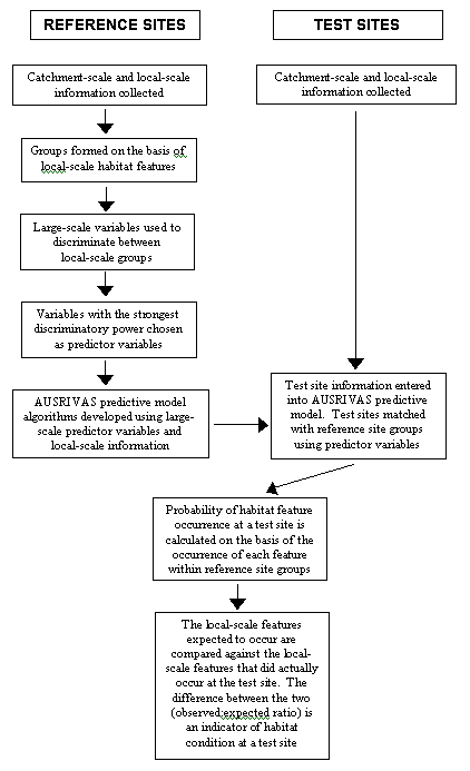
Habitat Predictive Modelling uses a similar approach to AusRivAS (see Section 2.2), but uses large-scale catchment features to predict local-scale stream physical habitat features (Davies et al., 2000). Local-scale habitat features are measured at reference sites, which are again defined as sites representing least impaired condition (Figure 2.7.1). Classification analysis is then used to form reference sites into groups containing similar habitat features. Large-scale catchment characteristics, usually measured off maps, are then used to discriminate among the local-scale groups and the variables with the strongest discriminatory power are chosen as predictor variables for use in the predictive model algorithm (Figure 2.7.1).
Figure 2.7.1 Schematic representation of Habitat Predictive Modelling and the assessment of habitat condition at a test site.
As with AusRivAS, the reference site information forms the templet against which test sites are compared to assess habitat condition (Figure 2.7.1). Local-scale habitat features are measured at the test sites, along with a suite of larger scale catchment characteristics that includes the predictor variables. These predictor variables are used to place test sites into the reference site groups that were formed on the basis of local-scale habitat features. The model then calculates the probability of occurrence of each habitat feature at a test site, based on the occurrence of that feature within the corresponding reference site groups. The habitat features predicted to occur at a test site are compared against the habitat features that were actually observed at the test site, with the difference between the two being an indication of habitat condition.
Habitat Predictive Modelling is based on the observation that stream systems are organised hierarchically (de Boer, 1992) and that there is a top down control on the expression of habitat features. For example, Frissell et al. (1986) identified five levels of hierarchical organisation: stream systems, segment systems, reach systems, pool/riffle systems and microhabitat subsystems. The characteristics of each level are constrained by physical processes operating at the next highest level. For example, climate and geology act at the larger stream system scale to constrain the expression of bedrock type, longitudinal profile and slope, which are characteristic of the segment scale. In turn, bedrock, longitudinal profile and slope constrain the development of reach systems (Frissell et al., 1986). Although Habitat Predictive Modelling does not aim to capture the same hierarchical levels as Frissell et al. (1986), the prediction of local-scale habitat features from catchment characteristics reflects the constraining relationships between physical processes operating at the large and small levels of the hierarchy. The catchment scale and local-scale variables used in the Habitat Predictive Modelling approach are listed in Table 2.7.1.
Habitat Predictive Modelling assesses stream condition by comparing the local-scale habitat features predicted to occur at a site in the absence of degradation, against the features that were actually observed at a site. The deviation between the two measures (observed:expected ratio) is an indication of habitat quality. This is the same process that is used in AusRivAS to detect biological impairment (see Section 2.2). However, in adapting a technique designed to detect biological impairment into a method for assessing habitat condition, several limitations have become apparent. Firstly, AusRivAS predicts the occurrence of macroinvertebrate taxon at a site, whereas, there is a need with habitat assessment to predict a more continuous type of data. Currently, the habitat predictive model addresses this by converting each local-scale habitat variable into categories, prior to classification. However, the use of categorical data can result in more than one category being predicted to occur at a site, which may result in a distorted observed:expected ratio (Davies et al., 2000). Secondly, the observed:expected ratio may provide a resolution that is too coarse to accurately reflect habitat condition. For example, one site assessed by Davies et al. (2000) demonstrated an observed:expected ratio of 0.57, which is indicative of impairment. However, examination of the raw data showed that the site actually contained more trees and shrubs than predicted, which indicates that riparian vegetation is not a contributing factor in the habitat impairment observed at this site. Thus, it is suggested that the habitat features predicted to occur should be checked against the observed habitat features to determine if the deviation between them actually represents damage to the stream habitat (Davies et al., 2000). Despite some analytical limitations of Habitat Predictive Modelling, the technique was successful in predicting small-scale habitat features, and represents a promising step forward for habitat assessment.
|
Large scale habitat variables
|
Local scale habitat variables
|
Habitat Predictive Modelling is a habitat based approach and thus, it does not attempt to integrate biological aspects. However, the method has the potential to link physical features with biota, particularly macroinvertebrates, in two ways: