M. Parsons, M. Thomas, R. Norris
Cooperative Research Centre for Freshwater Ecology
Monitoring River Health Initiative Technical Report Number 21
Environment Australia, 2002
ISSN 1447 1280
ISBN 0 642 54887 0
River health has traditionally been viewed from a biological perspective, because 'effects on biota are usually the final point of environmental degradation and pollution of rivers' (Norris and Thoms, 1999, p197). However, there is an inherent link between the potential health of biota, and the availability of physical habitat (Brierley et al., 1999). As such, assessment of river health from a biological perspective cannot proceed effectively when analysed in isolation from the factors that determine river structure and function. Geomorphic River Styles aims to address the physical structure and function components of river health. It is framed around 'direct linkage of vegetative and geomorphic process, providing an assessment of habitat availability along river courses, and hence indirect linkage to river ecology' (Brierley et al., 1996, p2).
Assessment of stream condition from a distinctly geomorphological perspective has many benefits to river managers, including:
Geomorphic River Styles is a procedure that provides 'a baseline survey of river character and behaviour, evaluating the physical controls on river structure at differing positions in catchments' (Brierley et al., 1996, p2). The procedure is set within a nested hierarchical framework (Frissell et al., 1986) and as such, it incorporates assessment of river structure at the catchment, reach and geomorphic unit scales (Brierley et al., 1996).
There are five stages in the assessment of river character and behaviour:
Stage one comprises both pre-field data collection and field data collection (Brierley et al., 1996). During the pre-field data collection component, catchment scale characteristics are measured off maps, or by using GIS capabilities (Table 2.5.1). Consideration is also given to historical and archival information about the catchment. In addition, the pre-field component involves identification of reach boundaries off 1:12000 air photographs and a range of reach scale characteristics is subsequently measured at each reach (Table 2.5.1). The reaches delineated off maps are used as sampling units in the field data collection component (Brierley et al., 1996), although the reaches are ratified in the field prior to data collection. Geomorphic units are identified within each reach and at representative locations, the characteristics of each geomorphic unit are recorded (Table 2.5.1). A detailed sediment analysis is also conducted in each geomorphic unit (Table 2.5.1).
In Stage two, data collected in the pre-field and field components are used to interpret river behaviour. This process involves several steps and follows the hierarchical framework. Firstly, the assemblage of geomorphic units is assessed, to provide insight into the formative processes within a reach (Brierley et al., 1996).
|
CATCHMENT CHARACTERISTICS Relief measures
Areal properties
Linear measurements
Other measures
REACH CHARACTERISTICS Channel planform
Confinement
Vegetation character
|
GEOMORPHIC UNIT CHARACTERISTICS Identification
Morphology and dimensions of geomorphic units
Hydraulic parameters
Vegetation character
Assemblage and connectivity of geomorphic units throughout the reach
Lateral stability of the channel
Sediment attributes
Sediment relations
|
Examples of some of the links between geomorphic units and formative processes that can be deduced from this stage are:
In the second interpretation step, reaches are amalgamated to form source, transfer, throughput and accumulation zones, based on the assemblage of geomorphic units and associated sediment relations along reaches. These 'process zones' represent the capacity of the stream to temporarily store and accumulate materials (Brierley et al., 1996). Thirdly, the catchment characteristics are used to determine the nature of the controls on river character and behaviour in each process zone (Brierley et al., 1996). The evolution of the river is then assessed in a historical context, and provides an indication of pre-disturbance stream characteristics. Lastly, the 'direct controls on habitat availability are assessed by analysis of changes to channel geometry and planform, the assemblage of geomorphic units within each process zone and the nature of altered associations that each of these geomorphic features have with riparian vegetation' (Brierley et al., 1996, p26).
The assessment of stream condition using Geomorphic River Styles is achieved using two approaches: comparison of contemporary stream character and behaviour with the conditions expected in undisturbed conditions; and prediction of future river character and behaviour based on extrapolation from contemporary behaviour, sediment storage, and/or theoretical notions of river behaviour (Brierley et al., 1996; Fryirs et al., 1996). The focus of both approaches is the behaviour of process zones, because each zone type may respond differently to disturbance and result in a particular assemblage of geomorphic units.
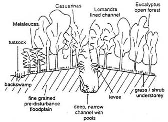
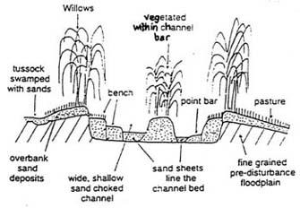
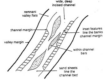
In the first approach, comparison of contemporary stream conditions with undisturbed conditions allows analysis of changes in both planform (Figure 2.5.1) and cross sectional (Figure 2.5.2) channel structure within different process zones. For example, in the Wolumla Creek Catchment on the South Coast of New South Wales (figure 2.5.1 and figure 2.5.2), river channel changes since human settlement of the area can be summarised as follows:
In the second approach to assessment of stream condition, prediction of likely future behaviour is made by extrapolation from contemporary behaviour, sediment storage (Figure 2.5.3) and relationships with theoretical notions of river behaviour (Figure 2.5.4) (Fryirs et al., 1996). For example, in the Wolumla Catchment, analysis based on sediment storage identified sites which were most sensitive to future sediment release (Figure 2.5.3) (Fryirs et al., 1996). Analysis based on theoretical river behaviour can identify the predictive relationships between variables related to river behaviour and channel geometry (Figure 2.5.4), which in turn, can be used to assist in setting targets for stream restoration or Rivercare programs. However, in the Wolumla Catchment, the classical notions of river behaviour do not apply (Fryirs et al., 1996). In addition, the ability of variables to predict channel geometry was highly variable among sub-catchments, highlighting the need for analysis of predictive relationships at the scale of sub-catchments (Fryirs et al., 1996).
| Pre-disturbance | Post disturbance | |
|---|---|---|
| Upland zones | |
|
| Mid-catchment zones | |
|
| Lowland zones | |
|
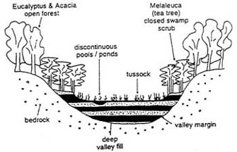
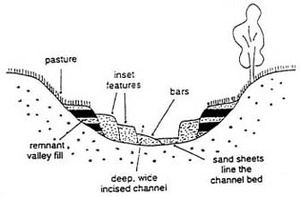
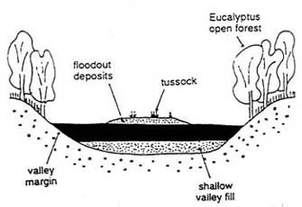
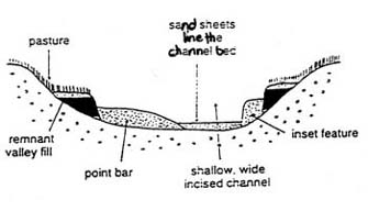
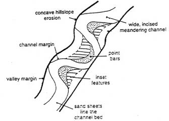
Figure 2.5.1 Planform view of pre-disturbance (left) and post-disturbance (right) channel character within upland, mid-catchment and lowland zones of the Wolumla Creek catchment. After Fryirs et al. (1996).
| Pre-disturbance | Post-disturbance | |
|---|---|---|
| Upland zones | 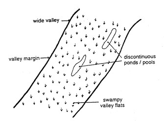 |
 |
| Mid-catchment zones | 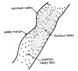 |
 |
| Lowland zones | 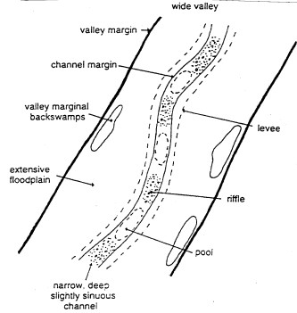 |
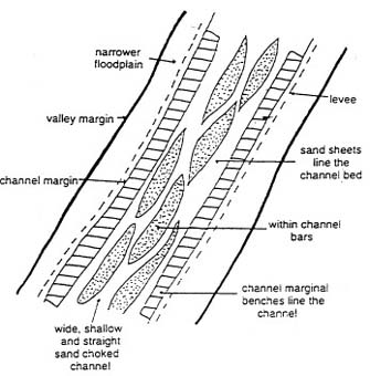 |
Figure 2.5.2a Cross-sectional view of pre-disturbance (left) and post-disturbance (right) channel character within upland, mid-catchment and lowland zones of the Wolumla Creek catchment. After Fryirs et al. (1996).
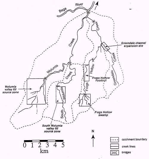
Figure 2.5.3 Identification of sensitive sites in the Wolumla Catchment, based on sediment storage. Frogs Hollow Swamp and Frogs Hollow floodout are intact features which if incised could supply significant volumes of material. Wolumla and South Wolumla valley fill source zones have had the majority of their fills removed, but a significant volume of material still remains stored within these zones. Greendale channel expansion site is an actively eroding transfer zone which is still supplying significant volumes of sediment to Frogs Hollow Creek and is the most sensitive site in the catchment. After Fryirs et al. (1996).
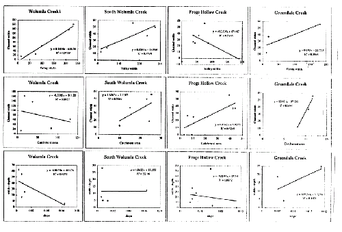
Figure 2.5.4 Predictive relationships between stream characteristics in sub-catchments of the Wolumla Catchment. After Fryirs et al. (1996).
Geomorphic River Styles is a geomorphological stream assessment method that relies heavily on sedimentary characteristics. As such, it does not directly measure the biota.
However, the process of deducing and predicting geomorphic stream characteristics and behaviour is essentially equivalent to deducing and predicting habitat availability because 'geomorphic processes determine the structure, or physical template, of a river system' (Brierley et al., 1999, p840; see also Cohen et al., 1996). In turn, this template provides the 'framework upon which a wide range of biophysical processes interact' (Brierley et al., 1999, p840; see also Resh et al., 1994; Townsend and Hildrew, 1994). Thus, Geomorphic River Styles may have the potential to merge geomorphology and ecology together under the common banner of a physical habitat template.
The implications of geomorphic channel changes for riverine ecology are evaluated by considering lateral and longitudinal connectivity of the river system, the hydrological regime, and the processing and storage of nutrients and organic matter (Brierley et al., 1996). In the Wolumla Catchment, some of the effects of channel behaviour on riverine ecology are reported as:
Despite the potential for Geomorphic River Styles to assess biotic habitat, there has been no direct testing of the relationships between different types of biota and different geomorphic units, or process zones. The view of what constitutes a functional habitat may differ significantly between the geomorphological and the biological perspective. For instance, is the distribution of macroinvertebrate communities within a catchment related to the distribution of source, input, throughput and accumulation zones within a catchment? If certain assemblages of geomorphic units are characteristic of process zones, do macroinvertebrate communities recognise and differentiate between these geomorphic units? Determination of these relationships through future research would provide a strong foundation for linking biotic condition with habitat condition, within a geomorphic process framework.