
erosion
Melissa Parsons, Martin Thoms and Richard Norris
Cooperative Research Centre for Freshwater Ecology
University of Canberra
Monitoring River Health Initiative Technical Report Number 22
Environment Australia, 2002
ISSN 1447-1280
ISBN 0 642 54888 9
| VARIABLE NAME | Bed stability rating |
| CATEGORY | Substrate |
| CONTROL OR RESPONSE | Response |
| OFFICE OR FIELD | Field |
| UNITS OF MEASUREMENT | Choice of five categories |
| INDICATES | Whether the bed is eroding or degrading |
The bed stability rating is an assessment of the overall stability of the whole sampling site. The bed stability rating is not a measure of localised patches of deposition or erosion within the sampling site (ie. normal sediment accumulation on a bar located at the inside of a stream bend, White and Ladson, 1999). Rather, this variable asks the question "does the sampling site, as an overall unit, show signs of large scale bed deposition or erosion that may continue outside the bounds of the sampling site?"
With a picture of the links between the sampling site and the surrounding catchment and adjacent river sections in mind, visually assess bed stability at the sampling site as one of the following categories:
| Category | Description | |
|---|---|---|
 |
Severe erosion |
Streambed scoured of fine sediments1. Signs of channel deepening. Bare, severely eroded banks. Erosion heads. Steep streambed caused by erosion. |
| Moderate erosion | Little fine sediment1 present. Signs of channel deepening. Eroded banks. Streambed deep and narrow. Steep streambed comprised of unconsolidated (loosely arranged and unpacked) material. | |
| Bed stable | A range of sediment sizes present in the streambed. Channel is in a 'relatively natural' state (not deepened or infilled). Bed and bar sediments are roughly the same size. Banks stable. Streambed comprised of consolidated (tightly arranged and packed) material, may be covered with algae. | |
| Moderate deposition | Moderate build-up of fine sediments1 at obstructions and bars. Streambed flat and uniform. Channel wide and shallow. | |
| Severe deposition | Extensive build up of fine sediments1 to form a flat bed. Channel blocked, but wide and shallow. Bars large and covering most of the bed or banks. Streambed comprised of unconsolidated (loosely arranged and unpacked) material. | |
1 Fine material generally corresponds to the sand, silt and clay sediment fractions
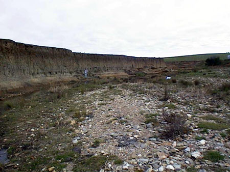
Examples of bed stability. Severe erosion (above)
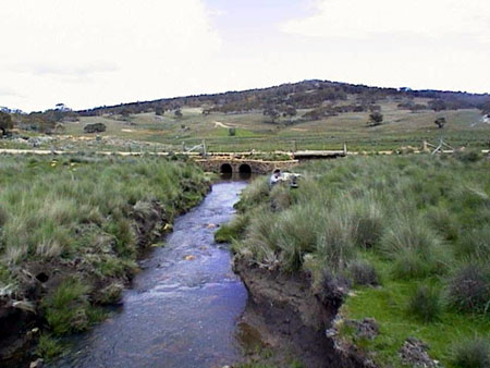
Examples of bed stability. Moderate erosion (above)
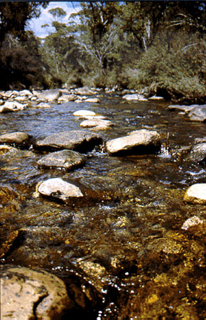
Examples of bed stability. Bed stable (above)
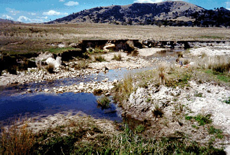
Examples of bed stability. Moderate deposition (above)
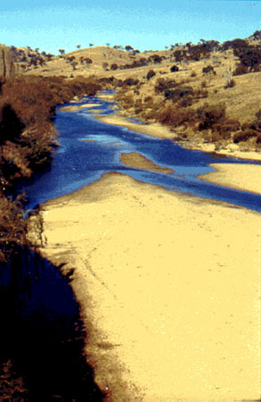
Examples of bed stability. Severe deposition (above)
Figure 5.21 Examples of bed stability. Severe erosion, moderate erosion, bed stable, moderate deposition and severe deposition.
Variable modified from the River Habitat Audit Procedure (Anderson, 1993a) and Index of Stream Condition (Ladson and White, 1999 and Department of Natural Resources and Environment, Victoria)
| VARIABLE NAME | Sediment matrix |
| CATEGORY | Substrate |
| CONTROL OR RESPONSE | Response |
| OFFICE OR FIELD | Field |
| UNITS OF MEASUREMENT | Choice of five categories |
| INDICATES | The relative composition of the matrix and interstitial components of the streambed sediments |
The sediment matrix variable is derived from sedimentological theories which state that two types of sediment can be characterised on the bed of a river:
Hence, riverbed sediments can be classified into five categories that represent the relationship between the framework and the matrix sediment components: open framework, matrix filled contact framework, framework dilated, matrix dominated and bedrock (Thoms, 1988). These categories also indicate the amount of interstitial space available within the riverbed.
After visual examination of the substratum and the bed along the whole length of the sampling site, assess the overall character of the sediment matrix as one of the following categories:
 |
Bedrock |  |
Framework dilated 32-60% fine sediment, low availability of interstitial spaces |
 |
Open framework 0-5% fine sediment, high availability of interstitial spaces |
 |
Matrix dominated >60% fine sediment, interstitial spaces virtually absent |
 |
Matrix filled contact framework 5-32% fine sediment, moderate availability of interstitial spaces | ||
| VARIABLE NAME | Substrate composition |
| CATEGORY | Substrate |
| CONTROL OR RESPONSE | Response |
| OFFICE OR FIELD | Field |
| UNITS OF MEASUREMENT | % cover of seven size categories |
| INDICATES | Substrate characteristics are directly related to geomorphological processes and in turn, substrate is a major factor controlling the occurrence of macroinvertebrates. |
Streambed sediment, or substrate, is visually assessed at each sampling site as the percent cover of each of seven size categories, within the area around the cross-section.
The area for assessment of substrate extends for 5m either side of the cross-section transect, regardless of the type of bedform types contained within that area:
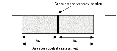
Within this 10m long area, assess the relative percent cover of each of the following size classes:
| Sediment category | Size |
|---|---|
| Bedrock | |
| Boulder | > 256mm |
| Cobble | 64 - 256mm |
| Pebble | 16 - 64mm |
| Gravel | 2 - 16mm |
| Sand | 0.06 - 2mm |
| Fines (silt and clay) | < 0.06mm |
The sum of all the substrate categories must equal 100%.
Stream substrate should be assessed to a depth of 10-20cm into the bed. In wadeable streams, sediment should be dislodged and both the surface and sub-surface layers examined. In deep pools or large rivers, sediment should be sampled using a grab sampler or similar device.
Overall substrate composition at the sampling site is calculated separately for each size category by averaging the percent cover obtained at each of the two or three cross-sectional areas used for assessment.
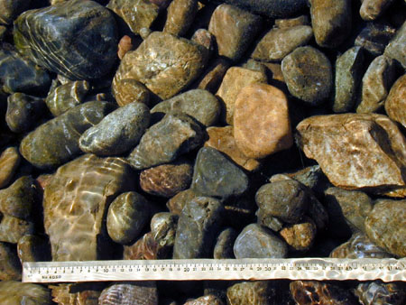
Examples of different sediment classes: cobble (above)
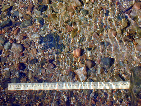
Examples of different sediment classes: gravel and pebble (above)
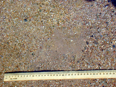
Examples of different sediment classes: sand and gravel (above).
Figure 5.22 Examples of different sediment classes: cobble (top), gravel and pebble (middle) and sand and gravel (bottom).
Variable derived from AusRivAS