VEGETATED
UNVEGETATED

VEGETATED

UNVEGETATED
Melissa Parsons, Martin Thoms and Richard Norris
Cooperative Research Centre for Freshwater Ecology
University of Canberra
Monitoring River Health Initiative Technical Report Number 22
Environment Australia, 2002
ISSN 1447-1280
ISBN 0 642 54888 9
| VARIABLE NAME | Extent of bars |
| CATEGORY | Physical morphology and bedform |
| CONTROL OR RESPONSE | Response |
| OFFICE OR FIELD | Field |
| UNITS OF MEASUREMENT | % extent of bars |
| INDICATES | Increased bar formation may be associated with increasing sedimentation or reduced instream flows |
A bar is a submerged or exposed ridge-like accumulation of sand, gravel or other alluvial material formed in the channel where a decrease in velocity induces deposition (Armantrout, 1998).
At each sampling site, visually estimate the percentage of the streambed area that protrudes to form a bar of any type (Figure 5.20). Also record the dominant sediment particle size of the bars. Streambed area is equivalent to the length of the sampling site and the width of the wetted channel (under baseflow conditions). Bars can be unattached (e.g. islands) or attached to the banks.
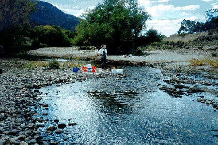
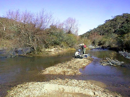
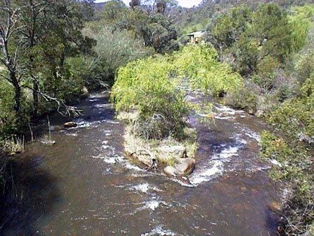
Figure 5.20 Examples of bars in a river channel
Variable derived from the River Habitat Audit Procedure (Anderson, 1993a).
| VARIABLE NAME | Type of bars |
| CATEGORY | Physical morphology and bedform |
| CONTROL OR RESPONSE | Response |
| OFFICE OR FIELD | Field |
| UNITS OF MEASUREMENT | Choice of nine categories |
| INDICATES | The types of bars present in a channel are indicative of channel behaviour and channel forming processes |
Indicate the presence of one or more of the following bar types along the length of the sampling site:
| bars absent | bars formed around obstructions | ||
| side/point bars VEGETATED |
braided channel | ||
| side/point bars UNVEGETATED |
infilled channel | ||
|
mid-channel island VEGETATED |
|
high flow deposits |
| mid-channel island UNVEGETATED | |||
Variable derived from the River Habitat Audit Procedure (Anderson, 1993a).
| VARIABLE NAME | Channel shape |
| CATEGORY | Physical morphology and bedform |
| CONTROL OR RESPONSE | Response |
| OFFICE OR FIELD | Field |
| UNITS OF MEASUREMENT | Choice of twelve categories |
| INDICATES | The shape of the channel influences many aspects of channel character including discharge, sediment transport and bedform features |
At each sampling site, examine the overall shape of the channel as one of the following categories:
| U shape Most common natural channel type |
Box Commonly encountered with severe gully erosion | ||
| Flat U shape | Wide box | ||
| Deepened U shape May be naturally incised channels |
V shaped | ||
| Widened or infilled | Trapezoid Engineered channel shape | ||
| Two stage Lowland channel with one bench |
Concrete V Engineered channel shape | ||
| Multi stage Lowland channel with >1 bench |
Culvert or pipe |
Variable modified from the River Habitat Audit Procedure (Anderson, 1993a).
| VARIABLE NAME | Bed compaction |
| CATEGORY | Substrate |
| CONTROL OR RESPONSE | Response |
| OFFICE OR FIELD | Field |
| UNITS OF MEASUREMENT | Choice of five categories |
| INDICATES | Partially determines the erodibility or stability of the bed material. |
After examination of the substratum and the bed along the length of the sampling site1, assess the overall character of bed sediment compaction as one of the following categories. The term 'dislodge' refers to the ability to pull individual rocks of different sizes from the streambed with the hands. The term 'overlapping' refers to the relative location of rocks on the streambed (ie. whether they sit on top of each other or next to each other).
| Tightly packed, armoured Array of sediment sizes, overlapping, tightly packed and very hard or impossible to dislodge | |
| Packed, but not armoured Array of sediment sizes, overlapping, tightly packed but can be dislodged with moderate effort | |
| Moderate compaction Array of sediment sizes, little overlapping, some packing but can be dislodged with moderate effort | |
| Low compaction (1) Limited range of sediment sizes, little overlapping, some packing and structure but can be dislodged very easily | |
| Low compaction (2) Loose array of fine sediments, no overlapping, no packing and structure and can be dislodged very easily |
1 In wadeable streams, the bed can be examined visually along the length of the sampling site. In large rivers, the bed should be examined in relation to the range of sediment sizes present at the sampling site (see substrate composition variable). Generally, beds comprised of gravel, sand and silt sediment sizes are not compacted and are easily moved. Thus, these bed types should be allocated to the low compaction (1) or (2) categories.
Variable derived from the River Habitat Audit Procedure (Anderson, 1993a).
| VARIABLE NAME | Sediment angularity |
| CATEGORY | Substrate |
| CONTROL OR RESPONSE | Response |
| OFFICE OR FIELD | Field |
| UNITS OF MEASUREMENT | Choice of six categories |
| INDICATES | Indicates the degree of material reworking. |
After visual examination of the substratum and the bed along the length of the sampling site, assess the overall angularity of the cobble, pebble and/or gravel sediment fractions as one of the following categories. Do not include bedrock in the assessment of angularity. Where the cobble, pebble AND gravel fractions are not present at a sampling site (e.g. in lowland rivers), select the 'not present' category.
 |
very angular |
 |
angular |
 |
sub-angular |
 |
rounded |
 |
well-rounded |
| cobble, pebble and gravel fractions not present |
Variable derived from the River Habitat Audit Procedure (Anderson, 1993a).