

Melissa Parsons, Martin Thoms and Richard Norris
Cooperative Research Centre for Freshwater Ecology
University of Canberra
Monitoring River Health Initiative Technical Report Number 22
Environment Australia, 2002
ISSN 1447-1280
ISBN 0 642 54888 9
| VARIABLE NAME | Form ratio |
| CATEGORY | Catchment characteristics |
| CONTROL OR RESPONSE | Control |
| OFFICE OR FIELD | Office |
| UNITS OF MEASUREMENT | Dimensionless |
| INDICATES | Catchment shape. |
Form ratio (Rf) is calculated for the catchment upstream of each site by dividing the area of the catchment by the squared length of the catchment:
where:
A = catchment area upstream of the sampling site
L = maximum length of the catchment along a line approximately parallel to the main stem
The units of A and L should be equal (ie. metres or kilometres) so as to make Rf dimensionless (Gordon et al., 1992).
| VARIABLE NAME | Mean catchment slope |
| CATEGORY | Catchment characteristics |
| CONTROL OR RESPONSE | Control |
| OFFICE OR FIELD | Office |
| UNITS OF MEASUREMENT | Dimensionless |
| INDICATES | Surface run-off rates, and is also related to drainage density and basin relief. |
Mean catchment slope (Sb) is calculated for the catchment upstream of each sampling site by dividing the difference in elevation between specific points in the catchment by catchment length:
where:
L = the maximum length of the catchment along a line basically parallel to the main stem
The components 0.85L, 0.10L and 0.75L correspond to points that are located at 85%, 10% and 75% of the catchment length respectively. The point of the stream source is 0% and the point of the sampling site is 100%.
| VARIABLE NAME | Mean stream slope |
| CATEGORY | Catchment characteristics |
| CONTROL OR RESPONSE | Control |
| OFFICE OR FIELD | Office |
| UNITS OF MEASUREMENT | m km-1 |
| INDICATES | Stream slope is related to water velocity. |
Mean stream slope (Sc) is calculated within the catchment area upstream of a sampling site by dividing the difference in elevation between the source and the sampling site by the total stream length in the catchment:
Elevation should be measured in m and the length of stream in the catchment area upstream of the sampling site in km (see the total stream length variable).
| VARIABLE NAME | Catchment geology |
| CATEGORY | Catchment characteristics |
| CONTROL OR RESPONSE | Control |
| OFFICE OR FIELD | Office |
| UNITS OF MEASUREMENT | % area of each geological type |
| INDICATES | Catchment geology is an important factor that controls many characteristics of a stream system (Schumm, 1977; Knighton, 1984), including the type of material available for weathering, transport and erosion, the network pattern and the topography of the catchment. |
Catchment geology should be measured as the area (km2) that is covered by each geology type within the catchment area upstream of a sampling site. To standardise across different sized catchments, geological areas should be converted to a percentage of the total catchment area upstream of a sampling site.
Geology types can be measured off geological maps using a planimeter. Alternatively, digitised versions of these geology maps may be available and the percent area of each geology type in a catchment can be calculated using a GIS. Information on the availability of digitised geology data can be found at the Australian Geological Survey Organisation's website (http://www.agso.gov.au).
In order to reflect regional conditions the geology types to be measured should be determined by each State or Territory, and may involve seeking advice from a geologist. As a minimum, the chosen geology types should reflect broad Statewide lithological patterns, but geology can be measured in more detail if required. The map scale used to measure catchment geology will reflect the level of detail required, although the availability of geological data may also dictate the scale of the map used. As a guide, the geological types used in the construction of the habitat predictive model of Davies et al. (2000) were alluvium, volcanics, metasediments and limestone, measured off a 1:100 000 scale map. If more detail is required, these geological types can be expanded and measured as alluvium, mafic volcanics, felsic volcanics, mafic intrusives, felsic intrusives, shale, siltstone & slate, conglomerates and limestone.
| VARIABLE NAME | Rainfall |
| CATEGORY | Catchment characteristics |
| CONTROL OR RESPONSE | Control |
| OFFICE OR FIELD | Office |
| UNITS OF MEASUREMENT | mean or median annual rainfall (mm) |
| INDICATES | Determines water availability for runoff and discharge, and effects vegetation cover and the potential for slope erosion. |
A measure of mean or median annual rainfall should be obtained for each sampling site. There are two options available for obtaining rainfall data for each sampling site:
Where available, modelled rainfall data can be used to obtain a reading of the long-term mean or median annual rainfall for each sampling site. BIOCLIM (part of ANUCLIM) is a modelled data package that is able to provide an annual average rainfall figure for any location within Australia. More detail on this package can be found at the Centre for Resource and Environmental Studies (CRES) website at http://cres.anu.edu.au/software.html.
At a lower level of detail that forgoes an actual measurement of rainfall for each sampling site, it may be possible to place sites into categories of mean annual rainfall to correspond with broad rainfall patterns across each State or Territory. For example, in NSW it would be possible to distinguish low rainfall areas in the Western part of the State from high rainfall coastal areas. The Bureau of Meteorology produces detailed climate maps showing broad rainfall bands for each State. More information can be found on the Bureau of Meteorology website at http://www.bom.gov.au/. Alternatively, the CLIMATE SURFACES package produced by CRES may provide data that is useful for determining broad annual rainfall categories. More information can be found on the CRES website at http://cres.anu.edu.au/software.html
| VARIABLE NAME | Valley shape |
| CATEGORY | Valley characteristics |
| CONTROL OR RESPONSE | Control |
| OFFICE OR FIELD | Field |
| UNITS OF MEASUREMENT | Choice of six categories |
| INDICATES | Valleys exert lateral and vertical control over the stream channel (Church, 1992) and influence the type of channel that will be present. |
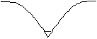
At each sampling site, visually assess the shape of the surrounding valley as one of the following categories:
|
steep valley |
| shallow valley | |
| broad valley | |
|
gorge |
| symmetrical floodplain | |
|
asymmetrical floodplain |
Variable modified from the River Habitat Survey (Raven et al., 1998)