Melissa Parsons, Martin Thoms and Richard Norris
Cooperative Research Centre for Freshwater Ecology
University of Canberra
Monitoring River Health Initiative Technical Report Number 22
Environment Australia, 2002
ISSN 1447-1280
ISBN 0 642 54888 9
| VARIABLE NAME | Channel slope |
| CATEGORY | Valley characteristics |
| CONTROL OR RESPONSE | Control |
| OFFICE OR FIELD | Office |
| UNITS OF MEASUREMENT | m km-1 |
| INDICATES | Stream gradient, which in turn influences sediment transport and discharge characteristics. |
Channel slope is the difference in elevation at the upstream and downstream ends of a stream segment, divided by the length of that segment:
Channel slope can be measured off 1:100 000 scale topographic maps.
The length of a segment is derived according to the bankfull width of the stream channel (see bankfull channel width variable) at the sampling site (Table 5.1). A stream segment is defined as 1000x the bankfull width of the channel. Streams wider than 50m have a segment length that is limited to 50km.
| Bankfull stream width (m) | Length of stream segment (km) |
|---|---|
| 5 | 5 |
| 10 | 10 |
| 20 | 20 |
| 50 | 50 |
| 100 | 50 |
The sampling site forms the midpoint of the stream segment (Figure 5.5). In the following example, the sampling site has a bankfull width of 15m. Thus, the corresponding segment length of 15km extends for 7.5km upstream and downstream of the sampling site.
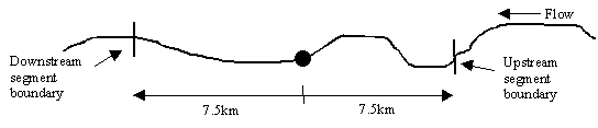
Figure 5.5 Placement of stream segments relative to the sampling site.
| VARIABLE NAME | Valley width |
| CATEGORY | Valley characteristics |
| CONTROL OR RESPONSE | Control |
| OFFICE OR FIELD | Office |
| UNITS OF MEASUREMENT | m |
| INDICATES | Relative degree of channel constriction. |
Valley width is the distance between the first topographic contours on either side of the channel, and should be measured off 1:100 000 scale topographic maps.
Measurements of valley width should be taken along a segment of stream, the length of which is equivalent to 1000x the bankfull channel width of the sampling site (see channel slope variable for further details on stream segments and bankfull channel width variable for further details on bankfull width). Replicate measurements of valley width should be made every 500m along the segment, and an average valley width derived from these replicate measurements.
| VARIABLE NAME | Sinuosity |
| CATEGORY | Planform channel features |
| CONTROL OR RESPONSE | Control |
| OFFICE OR FIELD | Office |
| UNITS OF MEASUREMENT | Dimensionless |
| UNITS OF MEASUREMENT | m |
| INDICATES | Planform channel pattern, which in turn relates to flow dynamics and sediment transport characteristics. |
Sinuosity (SI) is an assessment of the degree of irregularity in the path of a channel across the landscape (Figure 5.6) and is measured as the difference between channel length and valley length:
The sinuosity of each sampling site should be measured off small scale topographic maps, along a segment of stream with a length equivalent to 1000x the bankfull channel width (see channel slope variable for further details on stream segments and bankfull channel width variable for further details on bankfull width).
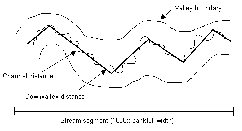
Figure 5.6 Example measurement of sinuosity. Channel distance is the 'exact' distance along the stream channel. Downvalley distance is the 'straight-line' distance along the channel, running approximately parallel to the valley boundaries.
| VARIABLE NAME | Catchment landuse |
| CATEGORY | Landuse |
| CONTROL OR RESPONSE | Control |
| OFFICE OR FIELD | Office |
| UNITS OF MEASUREMENT | % area of each landuse type |
| INDICATES | Potential disturbance to whole catchment channel, floodplain and slope morphology over time. |
Catchment landuse should be measured as the area (km2) that is covered by each landuse type within the catchment area upstream of a sampling site. To standardise across different sized catchments, landuse areas should be converted to a percentage of the total catchment area upstream of a sampling site.
Landuse should be measured using a GIS. Resolution of different landuse and land cover types will depend on the sensitivity of the initial classification image but as a guide, landuse types should include native forest cover, pine forest cover, native grassland cover, grazing pasture cover, crop cover and urban and other hard surfaces cover. Relevant landuse types will need to be reviewed by each State or Territory and adjusted to represent regional conditions and the availability of data.
| VARIABLE NAME | Local landuse |
| CATEGORY | Landuse |
| CONTROL OR RESPONSE | Control |
| OFFICE OR FIELD | Field |
| UNITS OF MEASUREMENT | Choice of eleven categories |
| INDICATES | Potential disturbances to local channel, floodplain and slope morphology over time. |
Local landuse is considered to be the landuse within 500m of the channel banks, along the area adjacent to the sampling site. Local landuse/land cover is visually assessed at each sampling site for the left and right banks as one of the following categories:
| Landuse category | Examples |
| Native forest | Native forest within a national park, nature reserve or similar |
| Native grassland (not grazed) | Native grasslands or shrub lands within a national park, nature reserve or similar |
| Grazing (native or non-native pasture) | Grazing activity on native or non-native pasture in farmland adjacent to the site |
| Exotic grassland (no grazing) | Non grazed exotic grasses such as manicured lawns, recreation areas or similar |
| Forestry | Recent native or pine forestry activity adjacent to the sampling site |
| Cropped | Row cropping activities such as sugar cane, wheat, horticulture etc. Also indicate whether cropping is irrigated or rainfed |
| Urban residential | Residential areas of cities and towns |
| Commercial | Shops, offices or similar |
| Industrial or intensive agricultural | Factories, tanneries, piggeries, feedlots or similar |
| Recreation | Picnic areas, playgrounds, campgrounds, municipal parks or similar |
| Other | Indicate the type of landuse present |
Variable derived from AusRivAS
Discharge regime has a significant influence on the morphology and dynamics of a river system (see Figure 1.1). The overall discharge regime of a river influences many 'response level' stream characteristics such as channel slope, width, depth, bedform geometry, meander wavelength, sinuosity and sediment transport (Knighton, 1994). Thus, it is important to include key measures of discharge regime as control variables in the physical assessment protocol.
Many hydrological variables are available that describe different aspects of discharge regime. Ladson and White (1999) reviewed a set of hydrology variables suitable for potential use within the Victorian Index of Stream Condition (ISC). These authors concluded that most hydrological variables reported in the literature were too detailed for the requirements of the ISC. Thus, the Hydrology Index of the ISC consists of three indicators that measure change in flow from 'natural' conditions: amended annual proportional flow deviation, daily flow variation due to change of catchment permeability and daily flow variation due to peaking hydroelectricity generation (Ladson and White, 1999).
More recently, the Ecosystem Health theme of the National Land and Water Resources Audit (NLWRA) has devised a set of four indices that indicate change in flow from 'natural' conditions. These are:
These indices provide a measure of the deviation in flow volume, duration and seasonal pattern. The physical assessment protocol will use these four NLWRA hydrology indices, because data is relatively easy to obtain for both reference and test sites, and the four indices encompass major aspects of stream discharge regime. Further details of each index are provided in the following pages.
The NLWRA database is currently under construction. However, it is expected that on completion of the modelling phase of the project, data on each of the indices will be available for most areas of Australia. Thus, hydrology variables for the physical assessment protocol will be collected directly from this database, for both reference and test sites. More information on the National Land and Water Resources Audit can be found at http://www.nlwra.gov.au/
| VARIABLE NAME | Index of mean annual flow |
| CATEGORY | Hydrology |
| CONTROL OR RESPONSE | Control |
| OFFICE OR FIELD | Office |
| UNITS OF MEASUREMENT | Dimensionless |
| INDICATES | Provides a measure of the difference in flow volume between current and natural conditions. |
For each sampling site, obtain the National Land and Water Resources Audit index of mean annual flow. The index of mean annual flow (A) returns a value of between 0 and 1, where 0 is the most modified mean annual flow condition and 1 is no change in mean annual flow from natural condition. The algorithm for the calculation of the index is:
where:
Qc = mean annual flow under current conditions
Qn= mean annual flow under natural conditions
Variable derived from the National Land and Water Resources Audit
| VARIABLE NAME | Index of flow duration curve difference |
| CATEGORY | Hydrology |
| CONTROL OR RESPONSE | Control |
| OFFICE OR FIELD | Office |
| UNITS OF MEASUREMENT | Dimensionless |
| INDICATES | Provides a measure of the overall difference between current and natural flow duration curves. |
For each sampling site, obtain the National Land and Water Resources Audit index of flow duration curve difference. The index of flow duration curve difference (M) returns a value of between 0 and 1, where 0 is the most altered flow difference and 1 is unaltered from natural conditions. The algorithm for the calculation of the index is:
where:
M = the difference from 1 of the proportional flow deviation, averaged over p daily flow percentile points
n = the natural flow value for percentile point i
c= the current flow value for percentile point i
The statistic M gives equal weighting to each percentile flow, from the lowest flow to the highest flow.
Variable derived from the National Land and Water Resources Audit
| VARIABLE NAME | Index of flow duration variability |
| CATEGORY | Hydrology |
| CONTROL OR RESPONSE | Control |
| OFFICE OR FIELD | Office |
| UNITS OF MEASUREMENT | Dimensionless |
| INDICATES | Provides a measure of flow regime variability at a daily/monthly time scale. |
For each sampling site, obtain the National Land and Water Resources Audit index of flow duration variability. The index of flow duration variability (Dv) returns a value of between 0 and 1, where 0 is the most altered flow duration variability and 1 is no change in flow duration variability from natural conditions. The algorithm for the calculation of the index is:
where:
Q90= the 90th percentile flow
Q10 = the 10th percentile flow
Q50= median flow
Then, to provide a measure of the difference between current and natural condition, the following equation is used:
where:
c = current conditions
n = natural conditions
Variable derived from the National Land and Water Resources Audit
| VARIABLE NAME | Index of seasonal differences |
| CATEGORY | Hydrology |
| CONTROL OR RESPONSE | Control |
| OFFICE OR FIELD | Office |
| UNITS OF MEASUREMENT | Dimensionless |
| INDICATES | Seasonal changes can occur as changes in amplitude (the difference between the highest and lowest monthly flows) or period (the months in which the flow is conveyed). |
For each sampling site, obtain the National Land and Water Resources Audit index of seasonal differences. This index contains two components: amplitude and change in period. Both components return a value of between 0 and 1, where 0 is the most altered seasonal difference and 1 is no change in seasonal difference from natural conditions. The algorithm for the calculation of seasonal amplitude (SA) is:
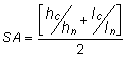
where:
h = the highest mean monthly flow
l = the lowest mean monthly flow
c = current conditions
n = natural conditions
The algorithm for the calculation of seasonal period (SP) is:
The statistic SP is defined as the difference from 1 of the sum of the differences between the numerical values of the months with the highest mean monthly flow (H) and the numerical values of the months with the lowest mean monthly flow (L) for current and natural conditions (subscript c and n respectively).
Variable derived from the National Land and Water Resources Audit