Melissa Parsons, Martin Thoms and Richard Norris
Cooperative Research Centre for Freshwater Ecology
University of Canberra
Monitoring River Health Initiative Technical Report Number 22
Environment Australia, 2002
ISSN 1447-1280
ISBN 0 642 54888 9
| VARIABLE NAME | Bankfull channel width |
| CATEGORY | Cross-sectional dimension |
| CONTROL OR RESPONSE | Response |
| OFFICE OR FIELD | Both |
| UNITS OF MEASUREMENT | m |
| INDICATES | Bankfull stage is an important control on alluvial channels (Gordon et al., 1992) |
Bankfull channel width is recorded directly at each cross-section as the sum of the stream width at the water mark and the left and right bank widths (see Figure 5.24). Bankfull channel width for the sampling site should be calculated as an average of all measurements taken at the two or three cross-sections in each sampling site.
| VARIABLE NAME | Bankfull channel depth |
| CATEGORY | Cross-sectional dimension |
| CONTROL OR RESPONSE | Response |
| OFFICE OR FIELD | Both |
| UNITS OF MEASUREMENT | m |
| INDICATES | Bankfull stage is an important control on alluvial channels (Gordon et al., 1992) |
Bankfull channel depth is the average depth of the channel at the bankfull level (see Figure 5.24). Calculation of bankfull channel depth at each cross-section involves the addition of bank height to the baseflow stream depth measurements (Figure 5.32).
The overall bankfull channel depth for the sampling site is calculated as the average channel depth of the two to three cross-sections measured at each sampling site.
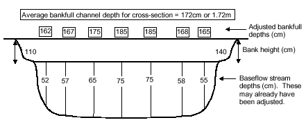
Figure 5.32 Example calculation of bankfull channel depth for one cross-section. Note that the only the smallest bank height (110cm) is added to the baseflow depths because if the banks are different heights, the smaller value represents the point where the water overtops the banks. Alternatively, the average (left and right) bank height can be added to the baseflow depths. Also, note that baseflow stream depths may have been previously adjusted if the water level at the time of sampling was below baseflow. Refer to the baseflow stream depth variable for information on these adjustments.
| VARIABLE NAME | Baseflow stream width |
| CATEGORY | Cross-sectional dimension |
| CONTROL OR RESPONSE | Response |
| OFFICE OR FIELD | Both |
| UNITS OF MEASUREMENT | m |
| INDICATES | Baseflow stream width is related to the amount of wetted habitat available under baseflow conditions |
Baseflow stream width is recorded directly at each cross-section as the stream width at the water mark (see Figure 5.24). Baseflow stream width for the sampling site should be calculated as an average of all measurements taken at the two or three cross-sections in each sampling site.
| VARIABLE NAME | Baseflow stream depth |
| CATEGORY | Cross-sectional dimension |
| CONTROL OR RESPONSE | Response |
| OFFICE OR FIELD | Both |
| UNITS OF MEASUREMENT | m |
| INDICATES | Baseflow stream depth is an indicator of channel size, which in turn influences discharge capacity. Baseflow stream depth is also related to the amount of wetted habitat area within the channel. |
Baseflow stream depth is the average depth of the channel at the watermark level (see Figure 5.24). Calculation of baseflow stream depth from the vertical water depth measurements recorded at each cross-section in the field may require some adjustments, to compensate for flows that were below baseflow levels at the time of sampling.
If the water surface at the time of sampling was equal to the baseflow water mark, then baseflow stream depth is simply calculated as the average of all the water depth measurements that were taken across the width of the cross-section.
If the water surface at the time of sampling was below the baseflow water mark, then the water depth measurements must be adjusted up to baseflow levels. To do this, add the vertical distance between the water surface and the baseflow mark to each of the water depth measurements (Figure 5.33).
Regardless of whether adjustments are required at an individual cross section, the overall stream depth for the sampling site is the average depth of the two to three cross-sections measured at each sampling site.
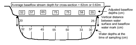
Figure 5.33 Example calculation of adjusted baseflow stream depths, for one cross-section. Note that the left bank vertical distance between the water surface and the baseflow water mark (20cm) is added to the water depths on the left of the channel and the right bank vertical distance (25cm) is added to the water depths on the right of the channel.
| VARIABLE NAME | Bank width |
| CATEGORY | Cross-sectional dimension |
| CONTROL OR RESPONSE | Response |
| OFFICE OR FIELD | Both |
| UNITS OF MEASUREMENT | m |
| INDICATES | Represents the width of the bank relative to baseflow stream width. In some situations, overly wide banks may indicate severe erosion. |
Bank width is recorded directly at the left and right banks of each cross-section (see Figure 5.24). Bank width should be averaged for the left and right banks of each cross-section, and then bank width for the sampling site should be calculated as an average of the two or three cross-sections in each sampling site.
| VARIABLE NAME | Bank height |
| CATEGORY | Cross-sectional dimension |
| CONTROL OR RESPONSE | Response |
| OFFICE OR FIELD | Both |
| UNITS OF MEASUREMENT | m |
| INDICATES | Bank height is related to channel confinement and to channel volume |
Bank height is recorded directly at the left and right banks of each cross-section (see Figure 5.24). Bank height should be averaged for the left and right banks of each cross-section, and then bank height for the sampling site should be calculated as an average of the two or three cross-sections in each sampling site.
| VARIABLE NAME | Bankfull width to depth ratio |
| CATEGORY | Cross-sectional dimension |
| CONTROL OR RESPONSE | Response |
| OFFICE OR FIELD | Both |
| UNITS OF MEASUREMENT | Dimensionless |
| INDICATES | Cross sectional channel shape at the bankfull level (Gordon et al., 1992; Armantrout, 1998) which in turn, determines the maximum cross sectional flow that can be transported through the system (Brierley et al., 1996) |
Width to depth ratio (W:D) is calculated for each cross section taken at each sampling site by dividing bankfull channel width by bankfull channel depth (see the bankfull channel width instruction sheet and the bankfull channel depth instruction sheet):
W:D = (W/D)
where:
W = bankfull channel width (m)
D = bankfull channel depth (m)
A width to depth ratio should be calculated for the two or three cross sections taken at a sampling site, and averaged to provide an overall width to depth ratio for the sampling site.
| VARIABLE NAME | Bankfull cross-sectional area |
| CATEGORY | Cross-sectional dimension |
| CONTROL OR RESPONSE | Response |
| OFFICE OR FIELD | Both |
| UNITS OF MEASUREMENT | m2 |
| INDICATES | Bankfull stage is an important control on alluvial channels (Gordon et al., 1992) |
Bankfull cross-sectional area is calculated for each cross-section using the AQUAPAK computer package. Data are prepared by deriving a set of coordinates from the horizontal distances across the bankfull width of the cross-section and the bankfull stream depth measurements (Figure 5.34). These coordinates are entered into AQUAPAK and bankfull cross-sectional area is calculated using the XSECT program.
The overall bankfull cross-sectional area for the sampling site is calculated as the average area of the two to three cross-sections measured at each sampling site.
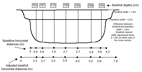
These measurements are entered into AQUAPAK as the following coordinates
| Horizontal distance (m) | Bankfull depth (m) |
|---|---|
| 0 | 0 |
| 2.2 | 1.62 |
| 2.7 | 1.67 |
| 3.3 | 1.75 |
| 3.9 | 1.85 |
| 4.5 | 1.85 |
| 5.2 | 1.68 |
| 5.6 | 1.65 |
| 7.8 | 0 |
Figure 5.34 Example derivation of AQUAPAK data for the calculation of bankfull cross-sectional area. Coordinates are comprised of adjusted bankfull horizontal distances and bankfull channel depth measurements. To derive adjusted bankfull horizontal distances, a factor that is equivalent to the width of each bank is added to each of the original baseflow horizontal distances. Instructions on the calculation of bankfull channel depths are provided with the bankfull channel depth variable.
| VARIABLE NAME | Bankfull wetted perimeter |
| CATEGORY | Cross-sectional dimension |
| CONTROL OR RESPONSE | Response |
| OFFICE OR FIELD | Both |
| UNITS OF MEASUREMENT | m |
| INDICATES | Bankfull wetted perimeter is related to the amount of wetted habitat area within the channel |
Bankfull wetted perimeter is the distance along the streambed and banks under bankfull conditions (Gordon et al., 1992). Wetted perimeter is calculated in the XSECT program of AQUAPAK, using the same coordinates used to calculate bankfull cross-sectional area (see bankfull cross-sectional area variable for instructions on the derivation of coordinates).
| VARIABLE NAME | Baseflow cross-sectional area |
| CATEGORY | Cross-sectional dimension |
| CONTROL OR RESPONSE | Response |
| OFFICE OR FIELD | Both |
| UNITS OF MEASUREMENT | m2 |
| INDICATES | Baseflow cross-sectional area is an indicator of channel size, which in turn influences discharge capacity. Baseflow cross-sectional area is also related to the amount of wetted habitat area within the channel. |
Baseflow cross-sectional area is calculated for each cross-section using the AQUAPAK computer package. Data are prepared by deriving a set of coordinates from the horizontal distances across the baseflow width of the cross-section and the baseflow stream depth measurements (Figure 5.35). These coordinates are entered into AQUAPAK and baseflow cross-sectional area is calculated using the XSECT program.
The overall baseflow cross-sectional area for the sampling site is calculated as the average area of the two to three cross-sections measured at each sampling site.
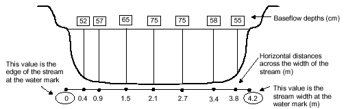
These measurements are entered into AQUAPAK as the following coordinates
| Horizontal distance (m) | Baseflow depth (m) |
|---|---|
| 0 | 0 |
| 0.4 | 0.52 |
| 0.9 | 0.57 |
| 1.5 | 0.65 |
| 2.1 | 0.75 |
| 2.7 | 0.75 |
| 3.4 | 0.58 |
| 3.8 | 0.55 |
| 4.2 | 0 |
Figure 5.35 Example derivation of AQUAPAK data for the calculation of baseflow cross-sectional area. Coordinates are comprised of the horizontal distances across the baseflow width of the stream and the baseflow depths. Instructions on the calculation of baseflow depths are provided with the baseflow stream depth variable. Note that when there is a difference between baseflow level and water level at the time of sampling, one additional coordinate can be added to each side of the cross-section. On the right side, the vertical coordinate would be the vertical distance between the water surface and the water mark and the horizontal coordinate would be the stream width at the water surface (see Figure 5.24). On the left side, the vertical coordinate would be the vertical distance between the water surface and the water mark and the horizontal coordinate would be the difference between baseflow stream width and stream width at the time of sampling, minus the distance of the first horizontal coordinate measured.
| VARIABLE NAME | Baseflow wetted perimeter |
| CATEGORY | Cross-sectional dimension |
| CONTROL OR RESPONSE | Response |
| OFFICE OR FIELD | Both |
| UNITS OF MEASUREMENT | m |
| INDICATES | Baseflow wetted perimeter is related to the amount of wetted habitat area within the channel |
Baseflow wetted perimeter is the distance along the streambed under baseflow conditions. Wetted perimeter is calculated in the XSECT program of AQUAPAK, using the same coordinates used to calculate baseflow cross-sectional area (see baseflow cross-sectional area variable for instructions on the derivation of coordinates).