Melissa Parsons, Martin Thoms and Richard Norris
Cooperative Research Centre for Freshwater Ecology
University of Canberra
Monitoring River Health Initiative Technical Report Number 22
Environment Australia, 2002
ISSN 1447-1280
ISBN 0 642 54888 9
| VARIABLE NAME | Factors affecting bank stability |
| CATEGORY | Bank characteristics |
| CONTROL OR RESPONSE | Response |
| OFFICE OR FIELD | Field |
| UNITS OF MEASUREMENT | Choice of eleven categories |
| INDICATES | Factors that may contribute to bank erosion and instability |
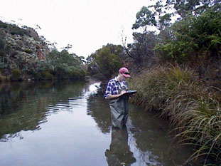
At each sampling site, indicate the presence of one or more of the following factors that may negatively influence the stability of either the left or right banks:
| Category | Example1 |
|---|---|
| Flow and waves | Bow waves from boats, or waves from turbulent flows |
| Seepage | From a landfill, water storage etc. |
| Runoff | Increased runoff from adjacent land that is unvegetated |
| Stock access | Cattle, sheep or horse access to the channel |
| Human access | Recreation point such as a picnic area or boat ramp |
| Feral animals | Goat, buffalo or horse access to the channel |
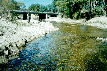
| Ford, culvert or bridge | Presence of bridges, culverts or fords that change channel dynamics |
| Clearing of vegetation | Forestry activity, land clearance to create grazing areas, riparian vegetation removal etc. |
| Reservoir release or irrigation offtake regime | Rapid release or draw down of instream flows that may increase the potential for bank slumping |
| Mining | Including gravel or sand extraction, existing or recent mining operations etc. |
| Drain pipes | Stormwater or waste-water pipes that may increase local discharge or turbulence |
| None | Banks are in excellent condition and are not impacted by any of the above factors |
Variable modified from the River Habitat Audit Procedure (Anderson, 1993a).
1 Examples are not exhaustive
| VARIABLE NAME | Large woody debris |
| CATEGORY | Instream vegetation and organic matter |
| CONTROL OR RESPONSE | Response |
| OFFICE OR FIELD | Field |
| UNITS OF MEASUREMENT | % cover of sampling site |
| INDICATES | Large woody debris is an important ecological component of lowland and upland streams, and can alter flow and other channel characteristics |
Visually estimate the percent cover of large woody debris within the bankfull channel area, along a length of stream that is equal to the length of the sampling site.
Large woody debris is defined as logs and branches that are greater than 10cm in diameter and greater than 1m in length (Gippel, 1995).
| VARIABLE NAME | Macrophyte cover |
| CATEGORY | Instream vegetation and organic matter |
| CONTROL OR RESPONSE | Response |
| OFFICE OR FIELD | Field |
| UNITS OF MEASUREMENT | % cover of different macrophyte types |
| INDICATES | Macrophytes are an important ecological component of streams and can alter flow and other channel characteristics. |
At each sampling site, visually estimate the percentage of the stream area covered by submerged, floating and emergent macrophyte types of any species (Figure 5.11). Stream area is equivalent to the length of the sampling site and the width of the wetted channel (under baseflow conditions).
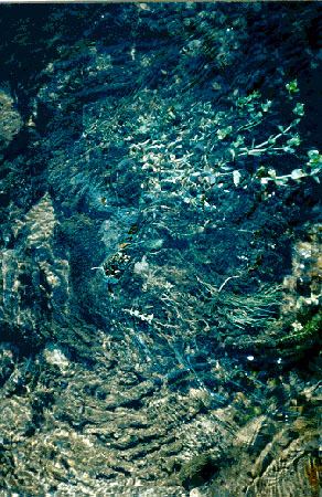
Figure 5.11 Examples of macrophyte types: submerged (above)
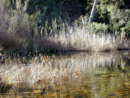
Figure 5.11 Examples of macrophyte types: emergent (above)
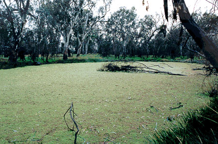
Figure 5.11 Examples of macrophyte types: submerged (top), emergent (middle) and floating (bottom).
Variable derived from the River Habitat Audit Procedure (Anderson, 1993a).
| VARIABLE NAME | Macrophyte species composition |
| CATEGORY | Instream vegetation and organic matter |
| CONTROL OR RESPONSE | Response |
| OFFICE OR FIELD | Field |
| UNITS OF MEASUREMENT | % cover of different macrophyte species |
| INDICATES | Macrophytes are an important ecological component of streams, and can alter flow and other channel characteristics. |
Record the presence of the common macrophyte species1 at the sampling site and indicate which of these are exotic species. The field guide titled "A Field Guide to Waterplants in Australia" (Sainty and Jacobs, 1994) will assist in macrophyte identification. If any species present at a site is unknown, collect a sample for identification at a later time.
Then, for each of the species present, both native and exotic, visually estimate the percent cover of this species within the stream area. Stream area is equivalent to the length of the sampling site and the width of the wetted channel (under baseflow conditions).
1 The macrophyte taxa initially included on the data sheets are a guide only and may need to be adjusted to suit regional conditions.
| VARIABLE NAME | Shading of channel |
| CATEGORY | Riparian vegetation |
| CONTROL OR RESPONSE | Response |
| OFFICE OR FIELD | Field |
| UNITS OF MEASUREMENT | Choice of five % shading categories |
| INDICATES | The amount of light reaching the channel is important for instream ecological processes and is an indirect relative measure of riparian vegetation density |
At each sampling site, visually estimate the percentage of the stream area that would be shaded by riparian vegetation when the sun is directly overhead (Figure 5.12). The stream area is equivalent to the length of the sampling site and the width of the wetted channel (under baseflow conditions).
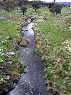
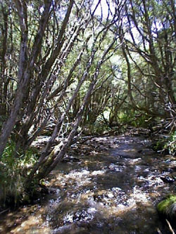
Figure 5.12 Examples of channel shading: <5% shading (left) and >76% shading (right).
Variable derived from AusRivAS
| VARIABLE NAME | Extent of bank trailing vegetation |
| CATEGORY | Riparian vegetation |
| CONTROL OR RESPONSE | Response |
| OFFICE OR FIELD | Field |
| UNITS OF MEASUREMENT | Choice of four categories |
| INDICATES | Vegetation that trails from the bank into the water provides an important habitat for aquatic biota |
Visually estimate the occurrence and density of trailing bank vegetation along the length of the sampling site as one of the following categories:
Trailing bank vegetation is the component of the terrestrial riparian vegetation that has direct contact with the water (under baseflow conditions) and which provides habitat and shelter for macroinvertebrates and fish (Figure 5.13). Trailing bank vegetation is generally found along the banks of slow flowing areas such pools and backwaters, although it is often present on the banks of riffles and runs.
|
|
Figure 5.13 Examples of trailing bank vegetation: extensive (left) and nil (right).
Variable derived from AusRivAS