Melissa Parsons, Martin Thoms and Richard Norris
Cooperative Research Centre for Freshwater Ecology
University of Canberra
Monitoring River Health Initiative Technical Report Number 22
Environment Australia, 2002
ISSN 1447-1280
ISBN 0 642 54888 9
5 Instructions for the Measurement of Each Variable (continued)
Response Variables (continued)
| VARIABLE NAME | Extent of bedform features |
| CATEGORY | Planform channel features |
| CONTROL OR RESPONSE | Response |
| OFFICE OR FIELD | Field |
| UNITS OF MEASUREMENT | % area of each feature |
| |
| INDICATES | Form process associations, which in turn reflect sediment availability and flow energy conditions acting at different positions along a river course. |
At each sampling site record the percentage area of the channel covered by each of the following bedform types, and where possible, also estimate the dimensions of each type. The sum of percentages for all bedform types should total 100%. Where the bedform type is not present at the sampling site, enter 0%.
 |
Waterfall
Height > 1m Gradient > 60O
|
 |
Cascade
Step height < 1m Gradient 5-60O
Strong currents |
 |
Rapid
Gradient 3-5O
Strong currents Rocks break surface |
 |
Riffle
Gradient 1-3O
Moderate currents Surface unbroken but unsmooth |
 |
Glide
Gradient 1-3O
Small currents Surface unbroken and smooth |
 |
Run
Gradient 1-3O
Small but distinct & uniform current Surface unbroken |
 |
Pool
Area where stream widens or deepens and current declines |
 |
Backwater
A reasonable sized (>20% of channel width) cut-off section away from the channel |
| VARIABLE NAME | Floodplain width |
| CATEGORY | Floodplain characteristics |
| CONTROL OR RESPONSE | Response |
| OFFICE OR FIELD | Field |
| UNITS OF MEASUREMENT | m |
| |
| INDICATES | The size of the floodplain |
At each sampling site with a distinct floodplain, visually estimate the average width of the floodplain on both sides of the channel (Figure 5.7). Where visibility is poor, examine the left and right banks separately. The longitudinal length of floodplain considered should be equal to the length of the sampling site. For confined channels with no floodplain, record floodplain width as zero.
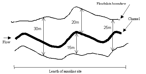
Figure 5.7 Example calculation of floodplain width. The overall average floodplain width for this example is 22.5m.
| VARIABLE NAME | Floodplain features |
| CATEGORY | Floodplain characteristics |
| CONTROL OR RESPONSE | Response |
| OFFICE OR FIELD | Field |
| UNITS OF MEASUREMENT | Choice of three categories |
| |
| INDICATES | Features of the floodplain are an indication of the relationship between the channel and the floodplain |
At each sampling site with a distinct floodplain, record the presence of one or more of the following floodplain features. If not visible locally from the sampling site, the presence of floodplain features should be recorded from maps or aerial photos, within a 20km radius of the sampling site. Flood channels and remnant channels can often be identified in the field, although identification of remnant channels may also require interpretation of maps or aerial photographs.
| Feature |
Description |
| Oxbows / billabongs |
Body of water occupying a former meander of a river isolated by a shift
in the stream channel (Figure 5.8) |
| Remnant channels |
Remnant channels of rivers formed during a different or previous hydrological
regime. May be infilled with sediment. Remnant channels are historical and
thus, currently inactive (i.e. no longer connected to the river) (Figure
5.8) |
| Prominent flood channels |
A channel that distributes water onto or through the floodplain and which
returns water to the main channel as the flood recedes. Flood channels are
currently active and connected to the river (Figure 5.8) |
| Scroll systems |
One of a series of short, crescentic, slightly sinuous strips or patches
of coarser alluvium formed along the inner bank of a stream meander and
representing the beginnings of a floodplain (Figure 5.8) |
| Splays |
A small alluvial fan or other outspread deposit formed where an overloaded
stream breaks through a levee and deposits its material on the floodplain
(Figure 5.8) |
| Floodplain scours |
A floodplain feature that has been formed by the concentrated clearing
and digging action of flowing water. Scour features may take many forms,
including linear, crescentic or erratic scour holes |
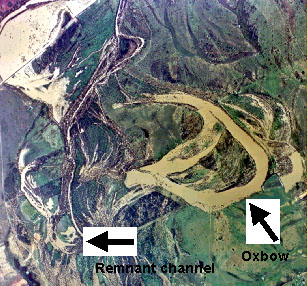
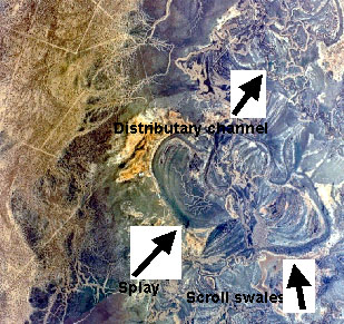
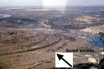
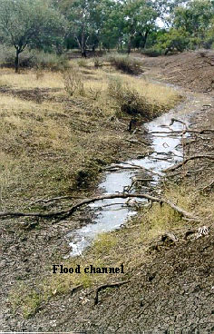
Figure 5.8 Examples of floodplain features, identified from aerial photographs and in the field.
| VARIABLE NAME | Bank shape |
| CATEGORY | Bank characteristics |
| CONTROL OR RESPONSE | Response |
| OFFICE OR FIELD | Field |
| UNITS OF MEASUREMENT | Choice of five categories |
| |
| INDICATES | The shape of the bank is related to the conveyance of water along the channel. |
Choose one category that represents the predominant shape of the left and right banks along the length of the sampling site.
 |
concave |
 |
convex |
 |
stepped |
 |
wide lower bench |
 |
undercut |
| VARIABLE NAME | Bank slope |
| CATEGORY | Bank characteristics |
| CONTROL OR RESPONSE | Response |
| OFFICE OR FIELD | Field |
| UNITS OF MEASUREMENT | Choice of five categories |
| |
| INDICATES | The slope of the bank is related to the conveyance of water along the channel, and to the susceptibility of the bank to erosion |
Choose one category that represents the predominant slope of the left and right banks along the length of the sampling site.
 |
vertical
Slope 80-90� |
 |
steep
Slope 60-80� |
 |
moderate
Slope 30-60� |
 |
low
Slope 10-30� |
 |
flat
Slope <10� |
| VARIABLE NAME | Bank material |
| CATEGORY | Bank characteristics |
| CONTROL OR RESPONSE | Response |
| OFFICE OR FIELD | Field |
| UNITS OF MEASUREMENT | % composition of seven sediment sizes |
| |
| INDICATES | Banks composed of certain sediment types may be more susceptible to erosion |
At each cross section, visually assess the percent composition of the bank sediments within the area lying 5m either side the cross-section. Left and right banks are assessed separately. Where the channel has a distinct upper and lower bank (i.e. benches), assess the lower bank only. The total composition of each of the following seven sediment size categories should equal 100%.
| Sediment category | Size |
| Bedrock | |
| Boulder | > 256mm |
| Cobble | 64 - 256mm |
| Pebble | 16 - 64mm |
| Gravel | 2 - 16mm |
| Sand | 0.06 - 2mm |
| Fines (silt and clay) | < 0.06mm |
| VARIABLE NAME | Bedrock outcrops |
| CATEGORY | Bank characteristics |
| CONTROL OR RESPONSE | Response |
| OFFICE OR FIELD | Field |
| UNITS OF MEASUREMENT | % cover of bedrock along banks |
| |
| INDICATES | Presence of bedrock may protect banks from erosion |
At each sampling site, visually assess the percentage of the left and right banks that contain bedrock outcrops (Figure 5.9 and 5.10).
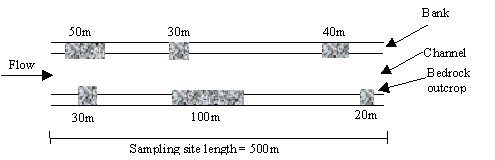
Figure 5.9 Example calculation of the percentage of bedrock outcrops along the banks of a sampling site that is 500m in length. On the left bank, the percent bank cover by bedrock outcrops is 24% (total 120m of bedrock outcrop along 500m of bank) and on the right bank, the percent cover is 30% (total 150m of bedrock outcrop along 500m of bank). The diagram is not to scale.
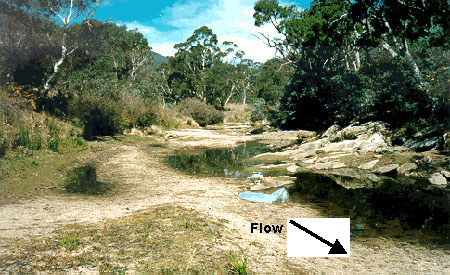
Figure 5.10 Example of a bedrock outcrop located along a bank. Note that the left bank contains bedrock outcrops but the right bank does not.
| VARIABLE NAME | Artificial bank protection measures |
| CATEGORY | Bank characteristics |
| CONTROL OR RESPONSE | Response |
| OFFICE OR FIELD | Field |
| UNITS OF MEASUREMENT | Choice of ten categories |
| |
| INDICATES | Presence of structures that have been built to protect the bank from erosion. |
At each sampling site, indicate the presence of one or more of the following bank protection features:
- rock wall or layer
- fence structures
- fenced stock watering points
- fenced human access
- logs strapped to bank
- concrete channel lining
- rip rap
- levee banks
- vegetation plantings
- other