Melissa Parsons, Martin Thoms and Richard Norris
Cooperative Research Centre for Freshwater Ecology
University of Canberra
Monitoring River Health Initiative Technical Report Number 22
Environment Australia, 2002
ISSN 1447-1280
ISBN 0 642 54888 9
| VARIABLE NAME | Latitude |
| CATEGORY | Position of the site in the catchment |
| CONTROL OR RESPONSE | Control |
| OFFICE OR FIELD | Field |
| UNITS OF MEASUREMENT | Degrees, minutes, seconds |
| INDICATES | The relative position of sampling sites across the landscape. |
The latitude of a site should be recorded in the field to the nearest second, using a GPS. When using a GPS, ensure that you record the datum as set on the GPS unit at the time you record your position.
Alternatively, if a GPS is not available in the field, the grid reference of each site can be derived from maps and converted to latitude using a GIS or GPS. Record the map details such as name, number, scale, datum and adjoining map names and numbers.
| VARIABLE NAME | Longitude |
| CATEGORY | Position of the site in the catchment |
| CONTROL OR RESPONSE | Control |
| OFFICE OR FIELD | Field |
| UNITS OF MEASUREMENT | Degrees, minutes, seconds |
| INDICATES | The relative position of sampling sites across the landscape. |
The longitude of a site should be recorded in the field to the nearest second using a GPS. When using a GPS, ensure that you record the datum as set on the GPS unit at the time you record your position.
Alternatively, if a GPS is not available in the field, the grid reference of each site can be derived from maps and converted to longitude using a GIS or GPS. Record the map details such as name, number, scale, datum and adjoining map names and numbers.
| VARIABLE NAME | Altitude |
| CATEGORY | Position of the site in the catchment |
| CONTROL OR RESPONSE | Control |
| OFFICE OR FIELD | Office |
| UNITS OF MEASUREMENT | metres above sea level (m asl) |
| INDICATES | The position of a sampling site within the catchment and physical stream processes that change along an altitudinal gradient. |
The altitude of each site should be read off 1:100 000 scale topographic maps.
| VARIABLE NAME | Distance from source |
| CATEGORY | Position of the site in the catchment |
| CONTROL OR RESPONSE | Control |
| OFFICE OR FIELD | Office |
| UNITS OF MEASUREMENT | km |
| INDICATES | The position of a sampling site within the catchment and physical stream processes that change along the river continuum. |
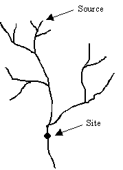
Distance from source is the distance between the source of the stream and the sampling site (Figure 5.1). Distance from source is measured off maps using a map wheel or similar device.
Figure 5.1 Example calculation of distance from source.
| VARIABLE NAME | Link magnitude |
| CATEGORY | Position of the site in the river system |
| CONTROL OR RESPONSE | Control |
| OFFICE OR FIELD | Office |
| UNITS OF MEASUREMENT | Dimensionless |
| INDICATES | Stream size within a river system context. |
Link magnitude is defined as the number of links upstream from the sampling site (Figure 5.2), and is calculated using the method of Shreve (1967). Link magnitude is preferable to the use of stream order, because it encompasses all contributing discharges upstream of a sampling site.
Link magnitude should be derived from maps. However, derivation of link magnitude is sensitive to changes in map scale and a consistent map scale should be used to measure this variable. A 1:25 000 map scale is recommended for the measurement of link magnitude, but where map coverage is limited, the lowest scale possible should be used.
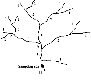
Figure 5.2 Example calculation of link magnitude. Link magnitude at the shown sampling site is 11.