Melissa Parsons, Martin Thoms and Richard Norris
Cooperative Research Centre for Freshwater Ecology
University of Canberra
Monitoring River Health Initiative Technical Report Number 22
Environment Australia, 2002
ISSN 1447-1280
ISBN 0 642 54888 9
3 Data Collection
The sampling design for the physical assessment protocol consists of two aspects. First, reference sites are stratified across the landscape according to broad climatic regions and geomorphological zones (see Part 2). Then, physical, chemical and habitat information is collected locally from each reference site, and in future, each test site. Any site at which data are collected is called a sampling site, and will be referred to by this name throughout this document.
The length of a sampling site is a function of stream size (Table 3.1), and is defined as 10 times the channel bankfull width. Upon arrival at each sampling site, bankfull width of the channel should be measured or estimated (see Part 5) and the length of the sampling site calculated. Use a tape measure to quantify the sampling site length, until distances can be estimated accurately by eye.
Table 3.1 Example calculation of sampling site length for streams of various bankfull widths
| Bankfull width |
Sampling site length |
| 110m | 1100m |
| 100m | 1000m |
| 80m | 800m |
| 50m | 500m |
| 20m | 400m |
| 10m | 100m |
| 5m | 50m |
| 2.5m | 25m |
To facilitate ease of movement along the length of the sampling site, the protocol has been designed in a manner that minimises the transportation of heavy or cumbersome sampling equipment over long distances (see cross-section variables section in Part 5). More information about field sampling is provided in Section 3.4.1 and a list of recommended field sampling equipment is provided in Appendix 2.
Variables for inclusion in the protocol were selected using a three-step process. Firstly, a comprehensive list of the physical and chemical variables collected in the Index of Stream Condition (Ladson and White, 1999), the River Habitat Audit Procedure (Anderson, 1993a), the River Habitat Survey (Raven et al., 1998), AusRivAS, River Styles (Brierley et al., 1996) and Habitat Predictive Modelling (Davies et al., 2000) was drawn up. The variables suggested at the Habitat Assessment Workshop (see Section 1.2.2) were also included. Then, each variable was examined in light of what it indicates about river condition, or how it relates to geomorphological process. Lastly, the list was trimmed of duplicated, highly variable, hard to measure and redundant variables, to form a final set for inclusion in the protocol.
Over 90 field and office based variables are included in the protocol (Table 3.2). The variables are divided into control and response types (see Section 3.3) and are grouped according to broad categories (Table 3.2). These broad categories represent the main physical components of river systems, and also incorporate factors that are important for ecological function. Site observations include factors that are collected in AusRivAS to indicate the general condition of a sampling site.
Additionally, there is a small amount of repetition in the choice of some variables. The repetition has been deliberately incorporated into the protocol and is analogous to the social survey practice of asking the same question in several differently worded versions. Repetition of some variables will ensure that a large set of high quality data, that covers all the important physical components, is available to construct the predictive models (see Section 3.4.1).
Table 3.2 Summary list of control and response
variables included in the physical assessment protocol. Office or field collection
indicates whether the variable is collected in the field, or collected in the
office. A description of the method used to collect each variable is provided
in Part 5.
| CONTROL VARIABLES |
| Category |
Variable |
Office or field collection |
| Position of the site in the catchment |
Latitude |
Field |
| Longitude |
Field |
| Altitude |
Office |
| Distance from source |
Office |
| Link magnitude |
Office |
| Water chemistry |
Alkalinity |
Field |
| Catchment characteristics |
Total stream length |
Office |
| Drainage density |
Office |
| Catchment area upstream of the site |
Office |
| Elongation ratio |
Office |
| Relief ratio |
Office |
| Form ratio |
Office |
| Mean catchment slope |
Office |
| Mean stream slope |
Office |
| Catchment geology |
Office |
| Rainfall |
Office |
| Valley characteristics |
Valley shape |
Field |
| Channel slope |
Office |
| Valley width |
Office |
| Planform channel features |
Sinuosity |
Office |
| Landuse |
Catchment landuse |
Office |
| Local landuse |
Field |
| Hydrology |
Index of mean annual flow |
Office |
| Index of flow duration curve difference |
Office |
| Index of flow duration variability |
Office |
| Index of seasonal differences |
Office |
| |
| RESPONSE VARIABLES |
| Category |
Variable |
Office or field collection |
| Physical morphology and bedform |
Extent of bars |
Field |
| Type of bars |
Field |
| Channel shape |
Field |
| Cross-sectional dimension |
Bankfull channel width |
Both |
| Bankfull channel depth |
Both |
| Baseflow stream width |
Both |
| Baseflow stream depth |
Both |
| Bank width |
Both |
| Bank height |
Both |
| Bankfull width to depth ratio |
Both |
| Bankfull cross-sectional area |
Both |
| Bankfull wetted perimeter |
Both |
| Baseflow cross-sectional area |
Both |
| Baseflow wetted perimeter |
Both |
| Substrate |
Bed compaction |
Field |
| Sediment angularity |
Field |
| Bed stability rating |
Field |
| Sediment matrix |
Field |
| Substrate composition |
Field |
| Planform channel features |
Planform channel pattern |
Office |
| Extent of bedform features |
Field |
| Floodplain characteristics |
Floodplain width |
Field |
| Floodplain features |
Field |
| Bank characteristics |
Bank shape |
Field |
| Bank slope |
Field |
| Bank material |
Field |
| Bedrock outcrops |
Field |
| Artificial bank protection measures |
Field |
| Factors affecting bank stability |
Field |
| Instream vegetation and organic matter |
Large woody debris |
Field |
| Macrophyte cover |
Field |
| Macrophyte species composition |
Field |
| Physical condition indicators and habitat assessment |
USEPA epifaunal substrate / available cover habitat score (high and low
gradient streams) |
Field |
| USEPA embeddedness habitat score (high gradient streams) or pool substrate
characterisation habitat score (low gradient streams) |
Field |
| USEPA velocity / depth regime habitat score (high gradient streams) or
pool variability habitat score (low gradient streams) |
Field |
| USEPA sediment deposition habitat score (high and low gradient streams) |
Field |
| USEPA channel flow status habitat score (high and low gradient streams) |
Field |
| USEPA channel alteration habitat score (high and low gradient streams) |
Field |
| USEPA frequency of riffles (or bends) habitat score (high gradient streams)
or channel sinuosity habitat score (high and low gradient streams) |
Field |
| USEPA bank stability habitat score (high and low gradient streams) |
Field |
| USEPA bank vegetative protection habitat score (high and low gradient
streams) |
Field |
| USEPA riparian vegetative zone width habitat score (high and low gradient
streams) |
Field |
| USEPA total habitat score (high and low gradient streams) |
Field |
| Channel modifications |
Field |
| Artificial features |
Field |
| Physical barriers to local fish passage |
Field |
| Riparian vegetation |
Shading of channel |
Field |
| Extent of trailing bank vegetation |
Field |
| Riparian zone composition |
Field |
| Native and exotic riparian vegetation |
Field |
| Regeneration of native woody vegetation |
Field |
| Riparian zone width |
Field |
| Longitudinal extent of riparian vegetation |
Field |
| Overall vegetation disturbance rating |
Field |
| Site observations |
Local impacts on streams |
Field |
| Turbidity (visual assessment) |
Field |
| Water level at the time of sampling |
Field |
| Sediment oils |
Field |
| Water oils |
Field |
| Sediment odours |
Field |
| Water odours |
Field |
| Basic water chemistry and nutrients |
Field |
| Filamentous algae cover |
Field |
| Periphyton cover |
Field |
| Moss cover |
Field |
| Detritus cover |
Field |
The variables included in the protocol are divided into control and response types and have very different functions in the construction of a predictive model.
Control variables – are large-scale environmental factors that control the expression of local-scale habitat features. Control variables are used as predictor variables in a predictive model and are analogous to the physical, chemical and habitat information collected in AusRivAS (see Section 1.3.2). Control variables are generally measured in the office (see Table 3.2 for exceptions). Also, control variables are usually large scale variables that are measured within the catchment area upstream of a site, or within a stream segment that is 1000 times the bankfull channel width. Exceptions are alkalinity, valley shape, local landuse, latitude and longitude, which are measured locally at the sampling site (Table 3.2).
Response variables – are local-scale environmental features. Response
variables are used to form groups with similar physical features and are
analogous to the macroinvertebrate information collected in AusRivAS (see Section
1.3.2). Response variables are all collected in the field and thus, are measured
on a local scale. The exception is planform channel pattern, which should be
verified using maps and aerial photographs.
Field data collection occurs in a similar manner as AusRivAS. Upon arrival at a sampling site, determine the bankfull channel width and calculate the length of the sampling site. Locate the sampling site so as to be 'representative' of the major bedform types present in the area. Then, follow the instructions given in Part 5 for the measurement of each variable. At larger sites, sampling may need to be conducted and recorded in sections, then combined. If this occurs, combination of data from different sections should be done while still at the sampling site, and overall observations of the site are still fresh in the memory!
Sampling should only be conducted under baseflow or low flow conditions. It is important not to sample under high flow conditions, because visibility of channel features will be reduced and the watermark will be obscured at cross-sections. In addition, health and safety issues should be considered at all times, but are of particular concern under high flow conditions.
Variables measured in the field have been selected to maximise information
about stream character, but are also designed to minimise the amount of sampling
equipment required (see Appendix 2). This facilitates ease of movement along
the entire length of the sampling site and it is vitally important that the
whole length of the sampling site is included in the assessment. Many local
variables are assessed over the area of the sampling site (see Part 5) and thus,
it is important to observe the overall status of each of these variables within
the entire sampling site. This will involve walking greater distances than is
generally encountered with AusRivAS sampling.
IMPORTANT
It is critical that all local scale variables are collected at every sampling
site. In the physical assessment protocol, the physical, chemical and habitat
variables are not used in the same way as in AusRivAS. The local scale variables
are used to form groups of sites with similar features. Subsequently, the features
present at a test site are compared against those present at a reference site
and form the basis for derivation of O/E scores (see Section 1.3.2). Failure
to measure a local physical, chemical or habitat variable at any reference site
is analogous to losing taxa out of a macroinvertebrate kicknet sample collected
for AusRivAS, and will ultimately detract from the robustness of physical
predictive models
Standardised and detailed instructions on the measurement and interpretation of each field-based variable are given in Part 5. It is important that sampling teams familiarise themselves with these methods prior to the commencement of field work (see Appendix 1). This manual should also be available in the field for reference and cross checking if necessary.
The suggested sequence of work at a typical sampling site is given in Figure 3.1. This sequence of work can be adjusted to suit the needs of different sampling teams, although any sequence of work must ensure that all parts of the stream are observed and that all variables are measured. The sequence of work may also need to be adjusted for large rivers that require boat or canoe access.
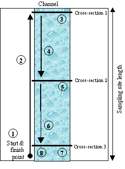
|
Sampling sequence
- Take water quality and GPS readings at the starting point
- Walk to one end of the sampling site. Closely observe the channel
along the way.
- Assess variables such as local impacts, local landuse, valley shape
etc. Perform cross-section 1 in an appropriate bedform type.
- Travel back towards the starting point, closely observing the channel
along the way. Stop at a point that is about mid-way along the sampling
site.
- Assess additional variables from previous observations of the channel.
Perform cross-section 2 in an appropriate bedform type.
- Travel the remainder of the way back to the starting point, again
closely observing the channel along the way.
- Assess remaining variables. Perform cross-section 3 in an appropriate
bedform type.
- Check that all variables have been recorded.
|
Figure 3.1 Suggested sequence of work at a wadeable sampling site with three cross-sections.
The physical assessment protocol is a rapid, semi-quantitative assessment method (see Section 1.3.1.4). When functional predictive models are fully implemented, this method will provide an assessment of physical stream condition that can be 'turned out' approximately 3-5 days after test site sampling. This turn out rate can be achieved because the majority of data collection occurs in the field. Laboratory processing of samples is not required, and is limited to the collection of office based predictor variables.
Further, the rapid aspect of the method is also applicable to field data collection, where sampling times have been substantially reduced in comparison to traditional geomorphological survey techniques. The approximate time required at different types of sampling sites is given in Table 3.3. However, sampling times may vary considerably depending on factors such as experience of the sampling team, site access, flow and weather conditions, ease of movement along the river, depth of the river, substrate type and periphyton cover, location of cross-sections and number of cross-sections. Thus, these times should be used as a guide only.
Table 3.3 Approximate sampling times for different
types of sampling sites. These figures are derived on the basis of field testing
of the protocol, but should be used as a guide only.
| Type of sampling site |
Approximate sampling time |
| Small-medium sized wadeable stream with three cross-sections,
none of which are in deep pools |
1 hour |
| Small-medium sized wadeable stream with three cross-sections,
one of which is in a deep pool |
1 hour 20 minutes |
| Large wadeable river with three cross-sections, two of which
are in deep pools, or which are difficult to access |
2 hours 30 minutes |
| Large non-wadeable river with two cross-sections, which require
access with a watercraft |
3 – 4 hours |
Standardised and detailed instructions on the measurement and interpretation of each office-based variable are given in Part 5. Many of the office-based variables, such as landuse and catchment characteristics can be measured using a GIS, while others will need to be measured directly off topographic maps. While not as critical as the collection of local scale variables, it is important to make an effort to measure all of the large-scale variables (i.e. those generally collected in the office). These variables are used as predictor variables and as such, have been included to cover the range of hierarchical links that may exist between local-scale and large-scale factors.
It should also be noted that for each office-based variable measured within a catchment (see Part 5), the term catchment always refers to the catchment area upstream of a site. This definition of a catchment standardises on the premise that regardless of catchment size, it is the large scale physical and geomorphological processes that occur upstream of a site, rather than downstream of a site, that determine the local scale features that will be found there.