Melissa Parsons, Martin Thoms and Richard Norris
Cooperative Research Centre for Freshwater Ecology
University of Canberra
Monitoring River Health Initiative Technical Report Number 22
Environment Australia, 2002
ISSN 1447-1280
ISBN 0 642 54888 9
The philosophy of the physical assessment protocol generally follows the same fundamental principles as rapid biological monitoring programs such as AusRivAS. These principles are predictive capability, use of the reference condition concept and use of rapid survey techniques. However, it is also important to incorporate principles of fluvial geomorphology into the protocol because there are fundamental differences between the properties of biological and physical information, and also between the way that information is used within a physically based predictive model. In a biological model, the relationship between physical information and biological information is fundamental whereas in a physical model, the relationship between large scale and small scale physical factors is fundamental (see Section 1.3.2 and Davies et al., 2000). Thus, the incorporation of geomorphological principles that relate small scale and large scale factors underpins the physical model in the same way that the deterministic link between macroinvertebrates and environmental features underpins the biological model. The founding principles of the physical assessment protocol are discussed in the following sections.
RIVPACS is a predictive modelling technique that was developed in the United Kingdom as a tool for the biological assessment of stream condition using macroinvertebrates (Wright, 2000). The predictive modelling approach used in RIVPACS (Wright et al., 1984) forms the basis of AusRivAS, the Australian biological assessment scheme that has been used successfully to assess the condition of several thousand sites nationwide (Davies, 2000; Simpson and Norris, 2000). The same predictive technique has also been used for development of the Canadian BEAST predictive models for rivers and lakes (Reynoldson et al., 1997; Reynoldson et al., 2000; Rosenberg et al., 2000) and for the prediction of macroinvertebrate composition using microhabitat features (Evans and Norris, 1997).
Recently, the predictive modelling approach has been applied to the assessment of stream habitat condition (Davies et al., 2000). This study used catchment scale features to successfully predict the occurrence of local scale habitat features and will be used as the basis for the physical assessment protocol. The major advantage to using predictive modelling for assessment of physical stream condition is the ability to predict the local scale habitat features that should be present at a site. Subsequently, it is then possible to compare what is expected to occur at a site, against what was actually observed at a site, with the deviation between these two factors being a quantitative indication of physical stream condition.
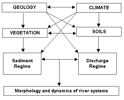
There are many interrelated geomorphological factors that operate within a river system. These geomorphological factors sit within a hierarchy of influence (Figure 1.1), where certain factors set the conditions within which others can form (de Boer, 1992; Bergkamp, 1995). Geology and climate are considered ultimate factors because they directly or indirectly control the formation of all other factors in the cascade (Schumm and Lichty, 1965; Lotspeich, 1980; Knighton, 1984; Frissell et al., 1986; Naiman et al, 1992; Montgomery, 1999). Geology and climate act to control to physiography of the catchment, the types of vegetation and soils that are present in a catchment, and the uses to which humans put the land. These factors control sediment and discharge regimes which in turn, sets the morphology and dynamics of the river system (Figure 1.1). Thus, in a fluvial system, physical and geomorphological factors operating at one level of the hierarchy directly influence the formation of factors at successively lower levels.
Figure 1.1 Interrelationships in a fluvial system. After Thoms (1998) and ideas presented in Schumm (1977) and Knighton (1984).
As a result of this hierarchy of influence within a river system, the deterministic links between different hierarchical levels, or scales, can be harnessed into 'raw material' for a predictive model. For example, Davies et al. (2000) used large-scale catchment characteristics to predict local-scale habitat features in an AusRivAS style predictive model and hence, was able to assess habitat condition. Similarly, Jeffers (1998) examined the River Habitat Survey Data (Raven et al., 1998) and was able to predict local-scale habitat features from the map-derived large-scale factors of altitude, slope, distance to source and height of source. The physical protocol will incorporate the hierarchical links within a river system by using large-scale characteristics (or control variables) to predict local-scale habitat features (or response variables, and See Part 3).
In addition to the deterministic links between geomorphological factors at different scales, the hierarchy of geomorphological interrelationships within a river system gives rise to the concept of hierarchical organisation of river systems. Probably the most familiar application of this concept is the stream classification framework of Frissell et al. (1986), which was designed to encompass the relationships between a stream and its catchment at a range of spatial and temporal scales. Five hierarchical levels were named in this scheme: stream systems, segment systems, reach systems, pool-riffle systems and microhabitat systems (Figure 1.2). Each system develops and persists at a characteristic spatial and temporal scale and smaller-scale systems develop within the constraints set by the larger-scale systems of which they are a part (Frissell et al., 1986). The spatial and temporal scales associated with each system subsequently translate into a set of defining physical factors that can be used to identify the hierarchical boundaries of each system within a watershed (Figure 1.2). For example, at the top of the hierarchy, stream systems within a watershed persist at large spatial scales and long time-scales (Figure 1.2) and are defined partly by ultimate factors such as geology and climate. This pattern of characteristic scales of persistence and physical factors continues through the hierarchy of segment, reach and pool/riffle systems until at the bottom of the hierarchy, microhabitats persist at small temporal and spatial scales and are defined by dependent factors such as substrate, water velocity and water depth (Figure 1.2). Thus, the division of a catchment into component hierarchical systems provides a practical representation of the complex interrelationships that exist between physical and geomorphological factors across different spatial and temporal scales.
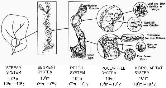
Figure 1.2 Hierarchical organisation of a stream system, and its habitat sub-systems. The approximate linear spatial scale (metres) and time scale of persistence (years) for a second or third-order mountain stream is also indicated for each system. After Frissell et al. (1986).
In the physical assessment protocol, data are collected at two spatial scales: a large catchment or segment-scale and a small sampling site scale. As mentioned above, large-scale factors are then used to predict the occurrence of small-scale factors. While these scales of measurement represent the deterministic links between geomorphological factors at different scales, they also correspond to the stream system or stream segment, and reach or pool/riffle scales of Frissell et al. (1986; and see Figure 1.2). Thus, the scales of measurement used in the protocol target differences between these specific hierarchical levels. The microhabitat is not considered as an explicit scale of measurement, because the protocol does not aim to predict physical factors at this level of detail. Additionally, the stratification of reference sites by regions and functional zones (see Part 2) is a function of the hierarchical organisation of river systems. Geomorphological processes related to the formation of regions and functional zones operate over large spatial scales and long time-scales and thus, sit at the top of the hierarchy (Figure 1.2). As a result, reference site stratification is targeted at the catchment and segment scales, because it is desirable to identify the broad (rather than fine) differences in river types that occur at these relatively large scales. Stratification of reference sites across a framework derived from geomorphological process will also ensure coverage of a range of deterministic linkages between large and small scale variables, that may change across regions and functional zones (Schumm, 1977).
The physical assessment protocol uses the reference condition concept. The reference condition concept underpins many biological assessment programs including the United Kingdom's RIVPACS, Australia's AusRivAS and Canada's BEAST predictive models (Reynoldson et al., 2000). The reference condition concept circumvents reliance on single control sites, and instead, aims to derive large sets of minimally disturbed reference sites that are formed into groups with similar biological and physical features (Reynoldson and Wright, 2000). Hence, the reference condition is defined as 'the condition that is representative of a group of minimally disturbed sites organised by selected physical, chemical and biological characteristics' (Reynoldson et al., 1997). Assessment of condition is subsequently achieved by comparing a test site against a group of multiple reference sites that would be expected to have similar features in the absence of degradation. Comparison of a test site against a reference condition derived from multiple sites improves confidence that observed degradation results from anthropogenic factors, rather than from inherent natural variation.
The reference condition concept was derived from work in the field of biological assessment of stream condition (Reynoldson and Wright, 2000), and has been applied successfully to the development of models that assess habitat condition (Davies et al., 2000). However, in applying the reference condition concept to physical assessment of stream condition there are two specific aspects that need to be considered: coverage of a range of different river types and definition of 'minimally disturbed' conditions. Reynoldson and Wright (2000) warn that the population of reference sites must represent the full range of conditions that are expected to occur at all other sites to be assessed. The physical assessment protocol addresses this aspect by stratifying reference sites on the basis of climatic and geological regions, and on the basis of geomorphological river types within regions (see Part 2). Selection of reference sites that represent 'minimally disturbed' conditions is also central to the reference condition concept, and requires consideration of the factors that may be acting to influence stream condition (Hughes et al., 1986; Hughes, 1995; Reynoldson and Wright, 2000). The physical assessment protocol addresses this by examining the large scale and local scale activities that may potentially be impacting the river system (see Part 2).
In the last three decades biological monitoring has moved away from the use of intensive quantitative surveys, toward the use of rapid, semi-quantitative stream assessment methods (Resh and Jackson, 1993). There are two main advantages of rapid survey techniques. Firstly, the effort and cost required to assess environmental condition is reduced relative to that needed in quantitative approaches, by using simplified sampling and sample processing techniques. Secondly, the results of these surveys can be summarised into a form that is easily understood by a range of non-specialists (Resh and Jackson, 1993; Resh et al., 1995). However, in achieving these advantages, the design of rapid methods must maintain an ability to detect a continuum of impaired and unimpaired conditions. Examples of rapid biological monitoring techniques that have been used successfully to examine stream condition include the United Kingdom's RIVPACS (Wright et al., 1984; Wright 2000), the United States' Rapid Bioassessment Protocols (Plafkin et al., 1989; Barbour et al., 1999) and Australia's AusRivAS predictive models (Marchat et al., 1999; Smith et al., 1999; Turak et al., 1999; Davies, 2000; Simpson and Norris, 2000).
In recent years, rapid assessment principles have been applied to physical stream assessment methods. Examples include Australia's River Habitat Audit Procedure (Anderson 1993a, 1993b, 1993c) and Index of Stream Condition (Ladson and White, 1999), the United Kingdom's River Habitat Survey (Raven et al., 1998) and the United States' HABSCORE habitat assessment, that is used to support the Rapid Bioassessment Protocols (Plafkin et al., 1989; Barbour et al., 1999). These assessment methods incorporate a range of physical characteristics, representing major geomorphological and habitat-template components. Variables included in these methods are measured using simplified techniques such as visual assessment and overall estimation, rather than the more time-consuming quantitative techniques such as surveying, replicated sedimentological particle size analysis, historical interpretation and transect vegetation surveys. The methods described above have demonstrated that it is possible to achieve a robust assessment of physical stream condition using data collected with rapid survey techniques, and as such, the physical assessment protocol will also use rapid techniques.
River systems can be viewed at distinctive hierarchical levels that represent a cascade of geomorphological interrelationships (see Section 1.3.1.2). The characteristic geomorphological processes that operate at each hierarchical level within a river system create the physical structure of a river (Frissell et al., 1986; Harper and Everard, 1998; Brierley et al., 1999) and in turn, the physical structure of a river provides a habitat matrix within which biophysical processes occur (Swanson, 1979; Brierley et al., 1999; Montgomery, 1999). Biologically, it has been proposed that habitat provides the templet on which evolution acts to forge characteristic life history strategies (Southwood, 1977; Southwood, 1988; Hildrew and Giller, 1994; Townsend and Hildrew, 1994). Accordingly, the environmental properties of any given habitat within a stream system will determine the types of macroinvertebrate communities found there. Therefore, stream habitat forms as a result of characteristic geomorphological processes and so conveniently sits between the physical forces which structure river systems and the biological communities that inhabit them (Harper and Everard, 1998).
There is much evidence to suggest that macroinvertebrates are strongly and deterministically linked to the availability of suitable habitat features. These features include substrate, discharge, hydraulics, riparian vegetation and water chemistry (Giller and Malmqvist, 1998). The physical assessment protocol is designed to complement biological assessments made using AusRivAS and thus, it will include factors that are important components of macroinvertebrate habitat. However, most of these environmental factors do not occur randomly within a river system, but rather, exist as a result of a suite of geomorphological processes that operate across a continuum of scales (Figure 1.1). The physical assessment protocol is also designed as a stand-alone method of physical stream assessment and as such, it will include geomorphological aspects of channel character. These channel characteristics may not appear to be directly related to macroinvertebrates, but are important structural and functional components of a river system.
As an overall method of stream assessment, the physical protocol works in a similar manner to AusRivAS (Figure 1.3). Physical, chemical and habitat information is collected from reference sites and used to construct predictive models, which are in turn, used to assess the condition of test sites. The physical assessment protocol comprises the following major components:
Reference site selection
Reference sites representing 'least impaired' conditions are selected, and stratified to cover a range of climatic regions and geomorphological river types (see Part 2).
Data collection
Each reference site is visited once and physical, chemical and habitat variables are measured using standardised methods (see Parts 3, 4 and 5). In the office, a suite of predictor variables is measured using standardised methods (see Parts 3 and 5).
Model construction
Predictive models are constructed using the same processes and analyses used in AusRivAS (Figure 1.3). However, in the physical assessment protocol, large-scale catchment characteristics are used to predict local scale features (Davies et al., 2000). Thus, the outputs of a physical predictive model are based on the occurrence of local scale features, rather than the occurrence of macroinvertebrate taxa (Figure 1.3).
Assessment of test sites
Assessment of stream condition involves the collection of local scale and large-scale physical, chemical and habitat information from test sites (Figure 1.3). This information is then entered into the predictive models and an observed:expected ratio is derived by comparing the features expected to occur at a site against the features that were actually observed at a site. The deviation between the two is an indication of physical stream condition.
As mentioned in Section 1.1.2, this document contains information on the selection of reference sites, and on the collection of field and office data. It does not provide technical information on the analytical procedures used to construct predictive models from reference site data, because these are documented in Simpson and Norris (2000).
There are several similarities and differences between the AusRivAS sampling protocol and the physical assessment protocol. In addition to the elements described in Section 1.3.1, similarities between the two protocols include measurement of similar types of habitat variables (see Part 5), use of some of the same reference sites (see Part 2), use of the same analytical techniques to build predictive models and production of the same model outputs (Figure 1.3). The experiences gained during the seven years of the National River Health Program will be invaluable throughout all stages of the physical assessment protocol.
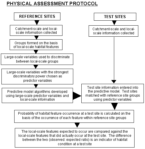
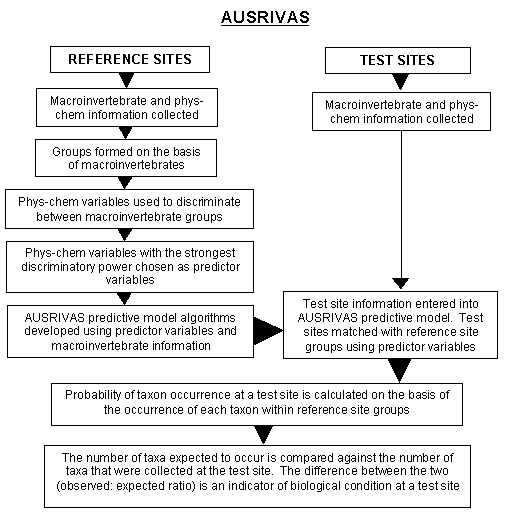
Figure 1.3 Overview of the analytical and assessment process used in the physical assessment protocol (left - top) and AusRivAS (right - below). [Note: In the original document the top figure (now 1.3a) was left and the bottom (now 1.3b) was right]
Although the outputs of the physical assessment protocol are complementary to the biological assessments made using AusRivAS, the protocol is designed to be a stand-alone stream assessment method. Thus, there are several unique preparation, sampling, processing and analytical aspects of the physical assessment protocol that should be noted. The physical assessment protocol differs from AusRivAS in the following ways: